IMAGES TAKEN NEAR TO
Norwood Road, BIRMINGHAM, B9 5HU
Introduction
This page details the photographs taken nearby to Norwood Road, B9 5HU by members of the Geograph project.
The Geograph project started in 2005 with the aim of publishing, organising and preserving representative images for every square kilometre of Great Britain, Ireland and the Isle of Man.

There are currently over 7.5m images from over14,400 individuals and you can help contribute to the project by visiting https://www.geograph.org.uk
Image Map
Images are licensed for reuse under creativecommons.org/licenses/by-sa/2.0
Notes
- Clicking on the map will re-center to the selected point.
- The higher the marker number, the further away the image location is from the centre of the postcode.
Image Listing (52 Images Found)
Images are licensed for reuse under creativecommons.org/licenses/by-sa/2.0
Image
Details
Distance
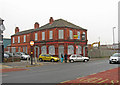
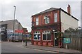
2
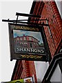
Shannon's (3) - pub sign, 222 Bordesley Green, Bordesley Green
A close look at the sign, which shows the pub, reveals that the signage and colour scheme is slightly different to what exists today.
Image
Image
Image: © P L Chadwick
Taken: 20 Nov 2010
0.03 miles
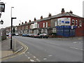
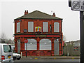
3
Shannon's (2), 222 Bordesley Green, Bordesley Green
Located on the corner of Norwood Road, and the main road known as Bordesley Green, this pub is closed and to let. Whether it will re-open as a pub is perhaps questionable. There are hardly any pubs left around here, and it is probably too far from the Birmingham City football ground to get much of the matchday trade.
This is an area of Birmingham where the tourists don't come. This road is a bit of an unattractive jumble of residential, shops, offices, the motor trade, industrial sites, other uses, and a few boarded up buildings as well. Next door on the right are industrial premises. A JCB or similar can be seen parked behind the fence.
Image
Image
Image: © P L Chadwick
Taken: 20 Nov 2010
0.03 miles
4
Shannon's (1), 222 Bordesley Green, Bordesley Green
Situated on one of the main roads in this area of Birmingham, both the road and area being known as Bordesley Green. The pub has closed and is currently to let. This area has changed greatly in recent decades and there is now not a lot of demand here for traditional public houses. This one is probably a little bit too far from Birmingham City's football ground, to benefit from the huge match day trade.
Image
Image
Image: © P L Chadwick
Taken: 20 Nov 2010
0.03 miles
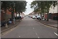
5
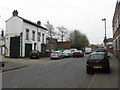
Cherrywood Road, looking south from Ronald Road
Image: © Peter Whatley
Taken: 29 Mar 2011
0.03 miles
6
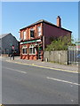
Shannon's public house
Rather contrary to expectations in Image taken 5 years ago, Shannon's has indeed re-opened, and had a bit of a facelift. In former times, notably in the mid 1960s when the Ordnance Survey were working their way through this area, it traded as the Coach and Horses inn. They placed a benchmark somewhere in the area of the corner nearest to us, but there was no sign of it when I looked; it may have been on an area of the building that's since been demolished.
Image: © Richard Law
Taken: 21 Apr 2015
0.04 miles
7
Shannon's public house on Bordesley Green, Birmingham
Image: © Ian S
Taken: 23 Jul 2021
0.04 miles
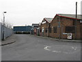
8
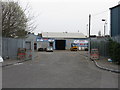
Bennetts Metal Recycling
One of numerous similar establishments in the surrounding area.
Image: © Peter Whatley
Taken: 29 Mar 2011
0.05 miles