IMAGES TAKEN NEAR TO
Green Lane, BIRMINGHAM, B9 5BW
Introduction
This page details the photographs taken nearby to Green Lane, B9 5BW by members of the Geograph project.
The Geograph project started in 2005 with the aim of publishing, organising and preserving representative images for every square kilometre of Great Britain, Ireland and the Isle of Man.

There are currently over 7.5m images from over14,400 individuals and you can help contribute to the project by visiting https://www.geograph.org.uk
Image Map
Images are licensed for reuse under creativecommons.org/licenses/by-sa/2.0
Notes
- Clicking on the map will re-center to the selected point.
- The higher the marker number, the further away the image location is from the centre of the postcode.
Image Listing (39 Images Found)
Images are licensed for reuse under creativecommons.org/licenses/by-sa/2.0
Image
Details
Distance
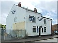
3
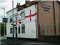
The St Andrews Tavern
This pub on Green Lane was previously known as The Black Horse.
Image: © Carl Baker
Taken: 21 Aug 2006
0.12 miles
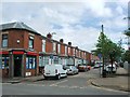
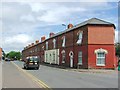
4
Green Lane, Small Heath (1)
At its junction with Victoria Street.
Image: © Richard Vince
Taken: 3 Dec 2022
0.14 miles
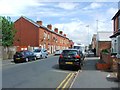
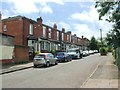
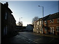
7
Grange Road, Small Heath
At its junction with Muntz Street.
Image: © Richard Vince
Taken: 3 Dec 2022
0.16 miles
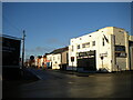
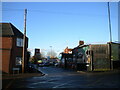
9
Muntz Street, Small Heath (1)
Seen from its junction with Grange Road.
Image: © Richard Vince
Taken: 3 Dec 2022
0.16 miles
