IMAGES TAKEN NEAR TO
Meadow Road, HENLEY-IN-ARDEN, B95 5LA
Introduction
This page details the photographs taken nearby to Meadow Road, B95 5LA by members of the Geograph project.
The Geograph project started in 2005 with the aim of publishing, organising and preserving representative images for every square kilometre of Great Britain, Ireland and the Isle of Man.

There are currently over 7.5m images from over14,400 individuals and you can help contribute to the project by visiting https://www.geograph.org.uk
Image Map
Images are licensed for reuse under creativecommons.org/licenses/by-sa/2.0
Notes
- Clicking on the map will re-center to the selected point.
- The higher the marker number, the further away the image location is from the centre of the postcode.
Image Listing (189 Images Found)
Images are licensed for reuse under creativecommons.org/licenses/by-sa/2.0
Image
Details
Distance
1
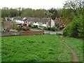
Houses on Alne Close
Houses built in the 1960s/70s on Alne Close viewed from the site of Beaudesert Castle.
Image: © Philip Halling
Taken: 29 Apr 2019
0.05 miles
2
Lane connecting Beaudesert Lane and Meadow Road, Beaudesert, Henley-in-Arden, Warks
The lane, which is a public footpath, also connects to a lane leading up to the site of Beaudesert Castle, of which only a single stone and earthworks are visible.
Image: © P L Chadwick
Taken: 3 Feb 2015
0.05 miles
3
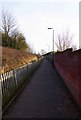
The eastern end of Beaudesert Lane, Beaudesert, Henley-in-Arden, Warks
The road turns right and becomes Alne Close, with modern housing. Ahead on the left is a kissing gate giving access to a number of public footpaths. Some way to its right is a hard surfaced lane which leads to Meadow Road and more streets with modern housing.
Image
Image: © P L Chadwick
Taken: 3 Feb 2015
0.07 miles
4
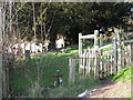
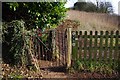
Churchyard footpath
Close to Beaudesert Lane, as other footpath climbs hill, another footpath runs north alongside the churchyard through this wooden gate
Image: © Michael Westley
Taken: 6 Mar 2011
0.07 miles
5
Kissing gate, Beaudesert Lane, Beaudesert, Henley-in-Arden, Warks
This rather battered kissing gate is at the eastern end of Beaudesert Lane. It gives access to a number of public footpaths, including the Millennium Way and the Heart of England Way.
Image
Image: © P L Chadwick
Taken: 3 Feb 2015
0.07 miles
6
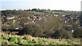
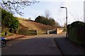
Beaudesert View
Housing and hillside view from hillside near site of former Motte and Bailey, approached from Beaudesert Lane.
Image: © Michael Westley
Taken: 6 Mar 2011
0.08 miles
7
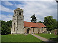
Beaudesert
The Norman built Church of St Nicholas.
Image: © David Stowell
Taken: 30 May 2005
0.08 miles
8
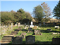
Churchyard of St Nicholas, Beaudesert
The gravestones are of many different ages and styles. Beyond the fence rises the natural mound on which the Normans built Beaudesert Castle, now a popular walk.
Image: © Robin Stott
Taken: 15 Oct 2011
0.08 miles
9
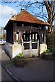
Lychgate of St. Nicholas Church, Beaudesert, Henley-in-Arden, Warks
The lychgate fronts onto Beaudesert Lane. The church itself is set back some way from the road and accessed from the drive which starts to the immediate left of the lychgate.
Image: © P L Chadwick
Taken: 3 Feb 2015
0.09 miles
10
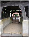
Lychgate, St. Nicholas Church, Beaudesert
Looking through Image] to Beaudesert Lane beyond.
Image: © Derek Harper
Taken: 28 Jun 2017
0.09 miles