IMAGES TAKEN NEAR TO
Oakhall Drive, SOLIHULL, B93 8UA
Introduction
This page details the photographs taken nearby to Oakhall Drive, B93 8UA by members of the Geograph project.
The Geograph project started in 2005 with the aim of publishing, organising and preserving representative images for every square kilometre of Great Britain, Ireland and the Isle of Man.

There are currently over 7.5m images from over14,400 individuals and you can help contribute to the project by visiting https://www.geograph.org.uk
Image Map
Images are licensed for reuse under creativecommons.org/licenses/by-sa/2.0
Notes
- Clicking on the map will re-center to the selected point.
- The higher the marker number, the further away the image location is from the centre of the postcode.
Image Listing (22 Images Found)
Images are licensed for reuse under creativecommons.org/licenses/by-sa/2.0
Image
Details
Distance
2
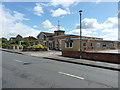
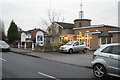
Dorridge Methodist Church on Mill Lane
The church has services every Sundaymorning; the info board also talks about monthly evening services, but doesn't make it clear which day of the week those are. The church website is currently at www.dorridgemethodists.org.uk
Image: © Richard Law
Taken: 11 Sep 2017
0.09 miles
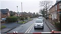
4
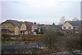
Enderby Close off Mill Lane, Dorridge B93
Small new houses.
Image: © Robin Stott
Taken: 12 Dec 2010
0.10 miles
5

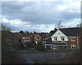
Victorian houses on Mill Lane, Dorridge
Image: © Richard Law
Taken: 11 Sep 2017
0.10 miles
6
Dorridge Methodist Church, Mill Lane, B93
Image: © Robin Stott
Taken: 12 Dec 2010
0.10 miles
8
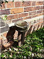
GWR boundary marker post
A cast-iron marker post at the side of the railway line, marking the limit of land owned, at the time, by the Great Western Railway Co, and dated 1881 as far as I can make out amongst the rust.
Image: © Richard Law
Taken: 11 Sep 2017
0.11 miles
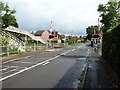
9
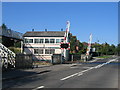
Bentley Heath Level Crossing
The only public road level crossing between Leamington and Birmingham. The box still proudly bears the name "Bentley Heath Crossing Signal Box" although these days all it controls is the Level Crossing itself. The signalling in the area is all controlled from Saltley.
Image: © David Stowell
Taken: 16 Jul 2005
0.11 miles
10
Bentley Heath Level Crossing
A sign of changing times, if ever there was one. David Stowell's 'first' for this square Image, taken in 2005, shows this crossing with a near-disused signal box in place. Well, that's that. It's gone now.
Image: © Richard Law
Taken: 11 Sep 2017
0.11 miles