IMAGES TAKEN NEAR TO
Earlswood Road, SOLIHULL, B93 8RW
Introduction
This page details the photographs taken nearby to Earlswood Road, B93 8RW by members of the Geograph project.
The Geograph project started in 2005 with the aim of publishing, organising and preserving representative images for every square kilometre of Great Britain, Ireland and the Isle of Man.

There are currently over 7.5m images from over14,400 individuals and you can help contribute to the project by visiting https://www.geograph.org.uk
Image Map
Images are licensed for reuse under creativecommons.org/licenses/by-sa/2.0
Notes
- Clicking on the map will re-center to the selected point.
- The higher the marker number, the further away the image location is from the centre of the postcode.
Image Listing (13 Images Found)
Images are licensed for reuse under creativecommons.org/licenses/by-sa/2.0
Image
Details
Distance
1
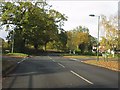
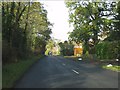
Crossroads on Earlswood Road
Beyond the junction the route ahead is Four Ashes Road.
Image: © Peter Whatley
Taken: 12 Nov 2011
0.05 miles
2
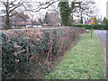
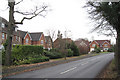
Hedge by Earlswood Road B93
Oaks, holly and bracken in a hedge, a feature of ancient Arden, a stone's throw from suburbia. The houses on the left, north of the road junction, are in Four Ashes Road.
Image: © Robin Stott
Taken: 12 Dec 2010
0.08 miles
3
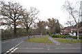
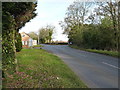
Southwest edge of Dorridge B93
The east end of Nailsworth Road meets Earlswood Road. The southeast end of Earlswood Road is at Image
Image: © Robin Stott
Taken: 12 Dec 2010
0.08 miles
4
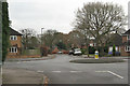
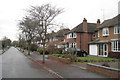
Southwest end of Rodborough Road B93
On these estates, oak trees are never out of view, both beyond the estate in the surrounding Arden countryside and those trees captured by streets, gardens and open spaces. Paradoxically, they humanise this kind of environment.
Woodchester Road is ahead; Besbury Close is to the left, both in Image; Nailsworth Road is to the right.
Image: © Robin Stott
Taken: 12 Dec 2010
0.08 miles
5
Besbury Close, Dorridge B93
At the end of the road is the traffic island in Image
Image: © Robin Stott
Taken: 12 Dec 2010
0.12 miles
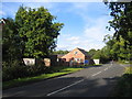
7
Junction of Earlswood Road onto Box Trees Road
Bentley Manor barns, here on the left, are currently a childcare/day nursery business.
Image: © Richard Law
Taken: 9 Jan 2019
0.18 miles
9
Bentley Manor
The Manor House, partly hidden by trees on the left, is at the junction with Earlswood Road, and along with the outbuildings, has been converted into a variety of small houses and flats.
Image: © David Stowell
Taken: 9 Oct 2005
0.20 miles
10

Bentley Manor
Bentley Manor and some of the outbuildings, all now converted into flats and housing.
Image: © David Stowell
Taken: 9 Oct 2005
0.20 miles