IMAGES TAKEN NEAR TO
Park Road, SOLIHULL, B91 3SU
Introduction
This page details the photographs taken nearby to Park Road, B91 3SU by members of the Geograph project.
The Geograph project started in 2005 with the aim of publishing, organising and preserving representative images for every square kilometre of Great Britain, Ireland and the Isle of Man.

There are currently over 7.5m images from over14,400 individuals and you can help contribute to the project by visiting https://www.geograph.org.uk
Image Map
Images are licensed for reuse under creativecommons.org/licenses/by-sa/2.0
Notes
- Clicking on the map will re-center to the selected point.
- The higher the marker number, the further away the image location is from the centre of the postcode.
Image Listing (112 Images Found)
Images are licensed for reuse under creativecommons.org/licenses/by-sa/2.0
Image
Details
Distance
1
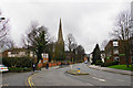
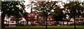
Park Road
Leading from Malvern Park towards the town centre. The view is dominated by St Alphege Church.
Image: © Bill Boaden
Taken: 19 Mar 2017
0.01 miles
2
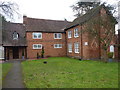
Malvern House - the old Grammar School
A mid 18th century, red brick adaptation of an earlier (17th century?) building. It was the town's grammar school until the 1880s, and is now a Grade II* listed https://www.britishlistedbuildings.co.uk/101076728-the-old-grammar-school-st-alphege-ward#.WmBK2vll-M8 office, granted as long ago as 1949.
Image: © Richard Law
Taken: 16 Jan 2018
0.03 miles
3
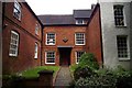
Entrance to Malvern House
Difficult to photograph because of its confined site, this Georgianised Tudor building in Park Road was originally the Old Grammar School, founded in 1560 under the headmastership of Edward Pole.
For a wider view and more information, see Image
Image: © Tiger
Taken: 11 Jun 2010
0.03 miles
4
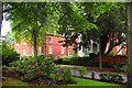
Malvern House
The historic 16th-century building with later additions, glimpsed through the trees from the site of the former Cedarhurst School in Park Road, well illustrates Solihull's civic motto "Urbs in rure" - the town in the country. It was the original home of the Old Grammar School (founded in 1560).
Dr Samuel Johnson, the great lexicographer, applied for the Headmastership here in 1735 but was rejected as "a very haughty, ill-natured gent" with a disconcerting habit of "distorting his fface [sic]".
After the main school relocated to Warwick Road in 1882, the building continued in use as the Lower School (Gaywood House) for several decades.
See also Image and for a view from the other side, with a link to the Grade II* listing, see Richard Law's Image
Image: © Tiger
Taken: 11 Jun 2010
0.03 miles
5
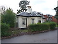
22, Park Road, Solihull
Formerly the lodge building at the entrance to Malvern Park, and built in the mid 19th century. It was Grade II listed https://www.britishlistedbuildings.co.uk/101281721-22-park-road-st-alphege-ward#.WmBMsvll-M8 in 1976.
Image: © Richard Law
Taken: 16 Jan 2018
0.03 miles
6
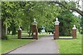
Gateway to Malvern Park
Malvern Park was laid out by the then Urban District Council in 1926 on land partly forming part of the estate of Malvern Hall and partly purchased from local farmers (Malvern Park Farm). The gateposts date from that year; the gates, like so much municipal ironwork, were requisitioned for scrap in the 1939-45 war and never replaced. In the background can be seen Joseph Boehm's fine equestrian group of the Image
This postcard from the late 1940s shows the gateway as it used to be, surrounded by a luxuriant herbaceous border http://pics.livejournal.com/jy100/pic/000eydbx
Image: © Tiger
Taken: 11 Jun 2010
0.06 miles
7
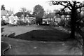
Rectory Gardens
A development of mainly semi-detached houses, centred round an attractive green with its ancient oak, and built by Biddle and Homer in the 1930s on part of the glebe lands of St Alphege. For a pre-war view from the builders' promotional postcard see http://ic.pics.livejournal.com/jy100/8671696/90690/90690_original.jpg (the iron chains that originally demarcated the front gardens were removed for scrap during the war and never replaced) and for a modern view see Image
Image: © Keith Yardley
Taken: Unknown
0.07 miles
8
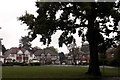
Rectory Gardens, NE corner
A view of this inter-war development round a green, showing three of the semi-detached pairs of houses and the single detached house, 64 years on from Image The properties have been well maintained and modernised by their occupiers while retaining much of their original charm and variety, and the ancient Arden oak still stands sentinel over the green, though it now has a somewhat incongruous No Waiting sign to keep it company.
Image: © Tiger
Taken: 16 Oct 2013
0.07 miles
9
Rectory Gardens, NW corner
Semi-detached houses 6-13 of this inter-war development are seen in this view. The spire of St Alphege's church, Solihull's most distinctive landmark, looms above the roof of no 8 where a loft conversion is in progress.
Image: © Tiger
Taken: 16 Oct 2013
0.07 miles
10
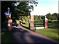
Gates to Malvern Park
An ancient footpath leads from Solihull town centre to the River Blythe by Warwick Road, passing through Malvern Park, once the deerpark of the Malvern Hall estate, now partly built over with suburbia, partly preserved as a civic park with a nature reserve beyond. Here the path enters the park.
Image: © A J Paxton
Taken: 10 Jul 2021
0.07 miles