IMAGES TAKEN NEAR TO
Whitefields Road, SOLIHULL, B91 3NS
Introduction
This page details the photographs taken nearby to Whitefields Road, B91 3NS by members of the Geograph project.
The Geograph project started in 2005 with the aim of publishing, organising and preserving representative images for every square kilometre of Great Britain, Ireland and the Isle of Man.

There are currently over 7.5m images from over14,400 individuals and you can help contribute to the project by visiting https://www.geograph.org.uk
Image Map
Images are licensed for reuse under creativecommons.org/licenses/by-sa/2.0
Notes
- Clicking on the map will re-center to the selected point.
- The higher the marker number, the further away the image location is from the centre of the postcode.
Image Listing (39 Images Found)
Images are licensed for reuse under creativecommons.org/licenses/by-sa/2.0
Image
Details
Distance
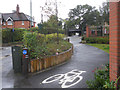
1
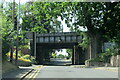
Railway bridge over Whitefields Road, Solihull
Image: © Roy Hughes
Taken: 19 Jul 2022
0.01 miles
2
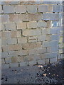
OS benchmark - Solihull, Whitefields Road railway bridge
An OS cutmark on the bricks of the railway bridge; originally levelled at 123.74m above Ordnance Datum Newlyn.
Image: © Richard Law
Taken: 28 Jan 2015
0.02 miles
3
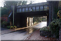
Whitefields Road, Solihull
The wet road glistens under the bridge carrying the former Great Western Railway main line between Birmingham and Leamington Spa.
Image: © Stephen McKay
Taken: 6 Dec 2021
0.02 miles
4
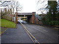
Railway bridge on Whitefields Road
Whitefields Road leads from the roundabout at the bottom of Church Hill Road, in the general direction of Hillfield. However, it's not a through-route for traffic, having been closed off a little to the SW of this point, and effectively replaced by Monkspath Hall Road.
Image: © Richard Law
Taken: 28 Jan 2015
0.02 miles

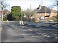
7
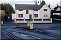
Whitefields Road, Solihull
Showing the junction with Church Hill Road. The house ahead with its white render and black window frames is quite distinctive.
Image: © Stephen McKay
Taken: 6 Dec 2021
0.05 miles
9
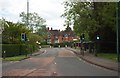
Church Hill Road, Solihull
Part of a residential road which in this direction is going away from the town centre. In the far distance the road going off on the right is Whitefields Road. The pedestrian crossing in Church Hill Road is traffic light controlled.
Image: © P L Chadwick
Taken: 24 May 2015
0.08 miles
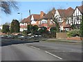
10
Widney Manor Road at Witley Avenue
House and tree-lined road typical of the area.
Image: © Peter Whatley
Taken: 11 Feb 2012
0.12 miles