IMAGES TAKEN NEAR TO
Widney Lane, SOLIHULL, B91 3JY
Introduction
This page details the photographs taken nearby to Widney Lane, B91 3JY by members of the Geograph project.
The Geograph project started in 2005 with the aim of publishing, organising and preserving representative images for every square kilometre of Great Britain, Ireland and the Isle of Man.

There are currently over 7.5m images from over14,400 individuals and you can help contribute to the project by visiting https://www.geograph.org.uk
Image Map
Images are licensed for reuse under creativecommons.org/licenses/by-sa/2.0
Notes
- Clicking on the map will re-center to the selected point.
- The higher the marker number, the further away the image location is from the centre of the postcode.
Image Listing (4 Images Found)
Images are licensed for reuse under creativecommons.org/licenses/by-sa/2.0
Image
Details
Distance
1
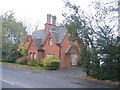
Hillfield Cottage
Another building on Widney Lane from before the housing developments of the last 30 years.
Image: © David Stowell
Taken: 30 Nov 2005
0.12 miles
2

Widney Woods
Inside Parish Poles, a small woodland also known locally as Widney Woods. The wood is believed to be owned by Solihull School, which once tried to get planning permission to build houses on it, which was refused by the local council. It is next to Hillfield Park and Blossomfield Cricket club.
Image: © Robin Jones
Taken: 30 Jan 2008
0.19 miles
3
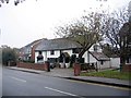
Widney Lane, Solihull
Much of this square has been covered by housing development as Solihull has expanded over the last 30 years. This old cottage on Widney Lane survives from times before the encroachment of the urban sprawl.
Image: © David Stowell
Taken: 30 Nov 2005
0.21 miles
4
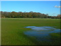
Hillfield Park and Widney Woods
Hillfield Park, with the woodland correctly named Parish Poles, and known locally as Widney Woods, in the background. Now public open space, it was until the 1970s used as a landfill site for Solihull's domestic waste. A tributary of the Cran Brook lies buried several feet below.
Image: © Robin Jones
Taken: 30 Jan 2008
0.22 miles