IMAGES TAKEN NEAR TO
Borley Close, SOLIHULL, B90 3FT
Introduction
This page details the photographs taken nearby to Borley Close, B90 3FT by members of the Geograph project.
The Geograph project started in 2005 with the aim of publishing, organising and preserving representative images for every square kilometre of Great Britain, Ireland and the Isle of Man.

There are currently over 7.5m images from over14,400 individuals and you can help contribute to the project by visiting https://www.geograph.org.uk
Image Map
Images are licensed for reuse under creativecommons.org/licenses/by-sa/2.0
Notes
- Clicking on the map will re-center to the selected point.
- The higher the marker number, the further away the image location is from the centre of the postcode.
Image Listing (8 Images Found)
Images are licensed for reuse under creativecommons.org/licenses/by-sa/2.0
Image
Details
Distance
1
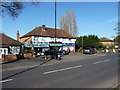
Small parade of shops on Solihull Lane
Solihull Lane here turns into Streetsbrook Road heading east, at the junction with Redstone Farm Road. the shops are a beautician (hair, nails, tanning etc), a hair salon, and a local convenience store.
Image: © Richard Law
Taken: 18 Apr 2018
0.07 miles
2
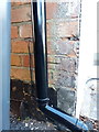
OS benchmark - Hall Green, 95 Solihull Lane
An OS cutmark on the side wall of the house, which was levelled in 1965 at 147.710m above Ordnance Datum Newlyn.
Image: © Richard Law
Taken: 18 Apr 2018
0.12 miles
3
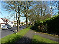
Streetsbrook Road just north of the Robin Hood cemetery
Designated as the B4025, Streetsbrook Road runs from just west of here (it's Solihull Lane before that) to a roundabout in Image not far from Solihull station.
Image: © Richard Law
Taken: 18 Apr 2018
0.13 miles
4
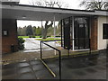
Robin Hood Cemetery
A cemetery operated and maintained by Solihull MBC.
Image: © Bill Boaden
Taken: 18 Feb 2019
0.17 miles
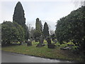
5

Robin Hood Cemetery
A cemetery operated and maintained by Solihull MBC.
Image: © Bill Boaden
Taken: 18 Feb 2019
0.18 miles
7
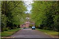
Robin Hood Crematorium
The cemetery chapel was built in 1931 for the then Solihull Urban District Council and enlarged in 1958 with the addition of a crematorium. This view from the east along the avenue of ancient Arden oaks, supplemented by more recent holly bushes, shows the earlier part of the building, which is in the Umbrian Revival style that was especially popular in the Midlands at that time.
Image: © Tiger
Taken: 30 Apr 2010
0.19 miles
8
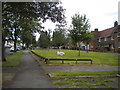
Wide verge along Redstone Farm Road, Hall Green
Image: © Richard Vince
Taken: 8 Jun 2019
0.24 miles