IMAGES TAKEN NEAR TO
Catesby Road, SOLIHULL, B90 2PA
Introduction
This page details the photographs taken nearby to Catesby Road, B90 2PA by members of the Geograph project.
The Geograph project started in 2005 with the aim of publishing, organising and preserving representative images for every square kilometre of Great Britain, Ireland and the Isle of Man.

There are currently over 7.5m images from over14,400 individuals and you can help contribute to the project by visiting https://www.geograph.org.uk
Image Map
Images are licensed for reuse under creativecommons.org/licenses/by-sa/2.0
Notes
- Clicking on the map will re-center to the selected point.
- The higher the marker number, the further away the image location is from the centre of the postcode.
Image Listing (4 Images Found)
Images are licensed for reuse under creativecommons.org/licenses/by-sa/2.0
Image
Details
Distance
2
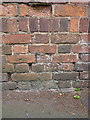
OS benchmark - Shirley, wall on Burman Road
An OS cutmark (now rather faded) on the weathered brickwork of a wall at the junction of Burman Rd with Bills Lane. It was originally levelled, probably in 1966, at 144.400m above Ordnance Datum Newlyn.
Image: © Richard Law
Taken: 7 Jun 2017
0.15 miles
3
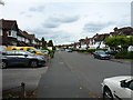
Along Hazeloak Road, Shirley
Late 1930s housing in the southern suburbs of Solihull.
Image: © Richard Law
Taken: 7 Jun 2017
0.20 miles
4
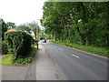
Bills Lane alongside Bills Wood
The area was almost completely undeveloped until the immediate post-war period, at which time this wood is mapped as being surrounded by agricultural land. How things have changed.
Image: © Richard Law
Taken: 7 Jun 2017
0.22 miles