IMAGES TAKEN NEAR TO
Fulford Hall Road, SOLIHULL, B90 1QZ
Introduction
This page details the photographs taken nearby to Fulford Hall Road, B90 1QZ by members of the Geograph project.
The Geograph project started in 2005 with the aim of publishing, organising and preserving representative images for every square kilometre of Great Britain, Ireland and the Isle of Man.

There are currently over 7.5m images from over14,400 individuals and you can help contribute to the project by visiting https://www.geograph.org.uk
Image Map
Images are licensed for reuse under creativecommons.org/licenses/by-sa/2.0
Notes
- Clicking on the map will re-center to the selected point.
- The higher the marker number, the further away the image location is from the centre of the postcode.
Image Listing (7 Images Found)
Images are licensed for reuse under creativecommons.org/licenses/by-sa/2.0
Image
Details
Distance
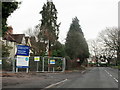
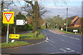
1
Tidbury Green
Looking north up Tilehouse lane from the crossroads with Yew Tree Farm on the opposite side of the road.
Image: © David Stowell
Taken: 25 Nov 2005
0.02 miles
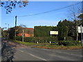
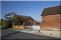
2
Yew Tree Farm, Tidbury Green
A well maintained, but still working farm near the centre of Tidbury Green.
Image: © David Stowell
Taken: 25 Nov 2005
0.02 miles
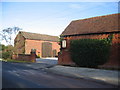
3
Lowbrook Lane Fulford Hall Crossroads Tidbury Green
Image: © Roy Hughes
Taken: 28 Dec 2018
0.04 miles
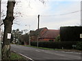
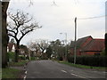
4
Tilehouse Lane, Tidbury Green
Tilehouse Lane seen from its junction with Lowbrook Lane.
Image: © Stephen McKay
Taken: 21 Dec 2012
0.05 miles
6
Lowbrook Lane Fulford Hall Crossroads Tidbury Green (2)
Image: © Roy Hughes
Taken: 28 Dec 2018
0.06 miles