IMAGES TAKEN NEAR TO
Grafton Road, SOLIHULL, B90 1NG
Introduction
This page details the photographs taken nearby to Grafton Road, B90 1NG by members of the Geograph project.
The Geograph project started in 2005 with the aim of publishing, organising and preserving representative images for every square kilometre of Great Britain, Ireland and the Isle of Man.

There are currently over 7.5m images from over14,400 individuals and you can help contribute to the project by visiting https://www.geograph.org.uk
Image Map (Loading...)


Getting Data...Please wait
Leaflet Map data © OpenStreetMap
Images are licensed for reuse under creativecommons.org/licenses/by-sa/2.0
Notes
- Clicking on the map will re-center to the selected point.
- The higher the marker number, the further away the image location is from the centre of the postcode.
Image Listing (8 Images Found)
Images are licensed for reuse under creativecommons.org/licenses/by-sa/2.0
Image
Details
Distance
2
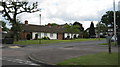
Greenslade Road, Solihull Lodge
Bungalows at junction with Yardley Wood Road
Image: © Michael Westley
Taken: 23 Jun 2011
0.17 miles
3
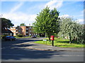
Oxhill road junction
The junction with Greenslade lane in this 1960s-ish residential development.
Image: © David Stowell
Taken: 26 May 2006
0.19 miles
4
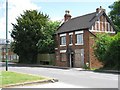
Boarded Residence, High Street, Maypole
Next to Prince of Wales Pub
Image: © Michael Westley
Taken: 28 May 2010
0.21 miles
5
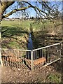
The Peterbrook stream in Daisy Farm Park
Rising in Highter's Heath the Peterbrook stream crosses Daisy Farm Park in an easterly direction and then turns directly south to Maypole Lane where it is culverted here under the busy main road. It continues on its way south to where it joins the River Cole by the Aqueduct in Solihull Lodge on Peterbrook Road.
Image: © planetearthisblue
Taken: 26 Mar 2020
0.22 miles
6
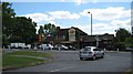
Prince of Wales Pub, Maypole
Public House at junction of Prince of Wales Lane and Maypole Lane, near Maypole
Image: © Michael Westley
Taken: 28 May 2010
0.22 miles
7
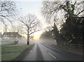
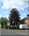
Frosty December Morning Maypole Lane Highter's Heath
Image: © Roy Hughes
Taken: 6 Dec 2014
0.23 miles
8

Stile and footpath, Peterbrook
Close to junction with Maypole Lane and Prince of Wales Lane, this footpath runs south towards Gay Hill Golf Course and Hollywood
Image: © Michael Westley
Taken: 28 May 2010
0.23 miles