IMAGES TAKEN NEAR TO
Hexton Close, SOLIHULL, B90 1ET
Introduction
This page details the photographs taken nearby to Hexton Close, B90 1ET by members of the Geograph project.
The Geograph project started in 2005 with the aim of publishing, organising and preserving representative images for every square kilometre of Great Britain, Ireland and the Isle of Man.

There are currently over 7.5m images from over14,400 individuals and you can help contribute to the project by visiting https://www.geograph.org.uk
Image Map
Images are licensed for reuse under creativecommons.org/licenses/by-sa/2.0
Notes
- Clicking on the map will re-center to the selected point.
- The higher the marker number, the further away the image location is from the centre of the postcode.
Image Listing (23 Images Found)
Images are licensed for reuse under creativecommons.org/licenses/by-sa/2.0
Image
Details
Distance
1
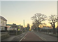
Frosty December Morning A435 High Street Solihull Lodge
Image: © Roy Hughes
Taken: 6 Dec 2014
0.05 miles
2
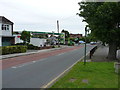
Junction of Yardley Wood Road with High Street in Solihull Lodge
The BP filling station has unleaded petrol at £1.189, and diesel at £1.199 per litre.
Image: © Richard Law
Taken: 7 Jun 2017
0.05 miles
3
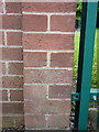
OS benchmark - Solihull Lodge, electrical building at school
An OS cutmark on the brickwork of a small electrical (meter?) building beside the school entrance; originally levelled in 1965 at 145.06m above Ordnance Datum Newlyn.
Image: © Richard Law
Taken: 7 Jun 2017
0.06 miles
4
5G Mast at Solihull Lodge
The most recent (28th February 2023) of three telecoms masts that encircle the Lodge pub in Solihull Lodge
Image: © planetearthisblue
Taken: 3 Mar 2023
0.07 miles
5
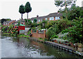
Canalside housing, Solihull Lodge
These 1960s houses have gardens with steep slopes down to the Stratford-upon-Avon Canal.
Image: © Roger D Kidd
Taken: 8 Sep 2008
0.08 miles
7

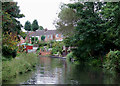
Canal-side gardens in Solihull Lodge
These houses have back gardens on to the Stratford-on-Avon canal.
They are part of a small 60's housing estate built on the site of Pear Tree Farm.
Image: © planetearthisblue
Taken: 10 Jul 2007
0.11 miles
8
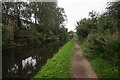
Stratford-upon-Avon Canal, Solihull Lodge
Here the canal passes by the gardens and 1960s housing built on the site of the old Pear Tree Farm http://www.geograph.org.uk/photo/490810.
The northern part of the canal dates from 1790s and was built with wide boats in mind, but the original plans had to be revised, and by 1803 the canal was open from King's Norton to Kingswood, with narrow locks. A further delay occurred until 1812, when the route was extended to Stratford, and operating by 1815
Image: © Roger D Kidd
Taken: 8 Sep 2008
0.11 miles
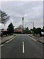
10

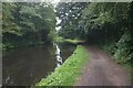
Stratford-upon-Avon Canal at Solihull High Street Bridge, bridge #7
Image: © Ian S
Taken: 20 Aug 2021
0.16 miles