IMAGES TAKEN NEAR TO
Johns Close, STUDLEY, B80 7EQ
Introduction
This page details the photographs taken nearby to Johns Close, B80 7EQ by members of the Geograph project.
The Geograph project started in 2005 with the aim of publishing, organising and preserving representative images for every square kilometre of Great Britain, Ireland and the Isle of Man.

There are currently over 7.5m images from over14,400 individuals and you can help contribute to the project by visiting https://www.geograph.org.uk
Image Map
Images are licensed for reuse under creativecommons.org/licenses/by-sa/2.0
Notes
- Clicking on the map will re-center to the selected point.
- The higher the marker number, the further away the image location is from the centre of the postcode.
Image Listing (20 Images Found)
Images are licensed for reuse under creativecommons.org/licenses/by-sa/2.0
Image
Details
Distance
1
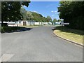
Sibcas Ltd, Studley
Manufacturer of modular and relocatable buildings.
Image: © Mike Dodman
Taken: 11 Aug 2024
0.07 miles
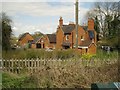
2
Studley & Astwood Bank railway station (site), Warwickshire
Opened in 1868 by the Midland Railway on the "Gloucester Loop" line from Redditch to Ashchurch, this station closed in 1962 to passengers, and completely in 1964.
Former forecourt, from Green Lane. Now a private residence.
Image: © Nigel Thompson
Taken: 5 Jun 2014
0.09 miles
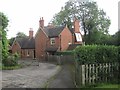
3
Former Studley railway station, Green Lane, Studley
This was the station serving Studley on the long-dismantled Ashchurch-Barnt Green railway. It explains the name and direction of Station Road, Studley. Other traces of the line are seen in Image and Image The station buildings appear now to be a private house with an adjoining business.
Image: © Robin Stott
Taken: 19 Apr 2013
0.09 miles
4
Along Jill Lane to The Slough
Looking north along Jill Lane towards its junction with The Slough which runs between Redditch and Studley.
Image: © Mike Dodman
Taken: 10 Jul 2024
0.11 miles
5

Factory of Simon & Dean Ltd, Brickyard Lane, Studley
The company manufactures workplace, storage and handling equipment in steel.
Image: © Robin Stott
Taken: 19 Apr 2013
0.11 miles
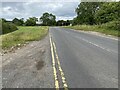
6
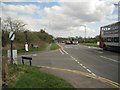
Staggered junction of Green Lane and The Slough A448 west of Studley
Image: © Robin Stott
Taken: 19 Apr 2013
0.11 miles
7

Semi-detached houses in Brickyard Lane, Studley
Evocative streetname.
Image: © Robin Stott
Taken: 19 Apr 2013
0.15 miles
8
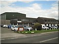
Eagle House, Renshaw Industrial Estate, The Slough A448 Studley
The industrial estate is extensive, wrapping round residential properties along the A448.
Image: © Robin Stott
Taken: 19 Apr 2013
0.15 miles
9

Small works off Brickyard Lane, Studley
Hopkins & Holloway manufacture specialist fishing tackle for anglers.
Image: © Robin Stott
Taken: 19 Apr 2013
0.16 miles
10

Junction, west end of Station Road, Studley
Station Road joins from the right. The view is from the Bromsgrove Road, A448, at the summit of Node Hill. The A448 continues west-northwest as The Slough towards Redditch. Traffic was unusually disrupted on this day because of a burst water main in High Street. Rough Hill Wood rises in the background.
Image: © Robin Stott
Taken: 19 Apr 2013
0.17 miles