IMAGES TAKEN NEAR TO
Brickhouse Lane, TAMWORTH, B79 9DE
Introduction
This page details the photographs taken nearby to Brickhouse Lane, B79 9DE by members of the Geograph project.
The Geograph project started in 2005 with the aim of publishing, organising and preserving representative images for every square kilometre of Great Britain, Ireland and the Isle of Man.

There are currently over 7.5m images from over14,400 individuals and you can help contribute to the project by visiting https://www.geograph.org.uk
Image Map
Images are licensed for reuse under creativecommons.org/licenses/by-sa/2.0
Notes
- Clicking on the map will re-center to the selected point.
- The higher the marker number, the further away the image location is from the centre of the postcode.
Image Listing (5 Images Found)
Images are licensed for reuse under creativecommons.org/licenses/by-sa/2.0
Image
Details
Distance
1
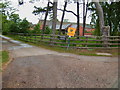
For Sale
One of the converted barns is up for sale at Park Farm
Image: © John Poyser
Taken: 10 May 2007
0.01 miles
4
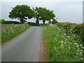
Passing place
One of several passing places on this single track road from Elford to Park Farm.
Image: © John Poyser
Taken: 10 May 2007
0.21 miles
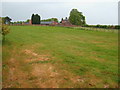
5
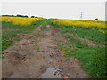
Arable fields
By walking up the track from Park Farm it is possible to get this photo.
Image: © John Poyser
Taken: 10 May 2007
0.25 miles