IMAGES TAKEN NEAR TO
Redhill Close, TAMWORTH, B79 8EJ
Introduction
This page details the photographs taken nearby to Redhill Close, B79 8EJ by members of the Geograph project.
The Geograph project started in 2005 with the aim of publishing, organising and preserving representative images for every square kilometre of Great Britain, Ireland and the Isle of Man.

There are currently over 7.5m images from over14,400 individuals and you can help contribute to the project by visiting https://www.geograph.org.uk
Image Map (Loading...)


Getting Data...Please wait
Leaflet Map data © OpenStreetMap
Images are licensed for reuse under creativecommons.org/licenses/by-sa/2.0
Notes
- Clicking on the map will re-center to the selected point.
- The higher the marker number, the further away the image location is from the centre of the postcode.
Image Listing (6 Images Found)
Images are licensed for reuse under creativecommons.org/licenses/by-sa/2.0
Image
Details
Distance
1
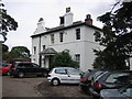
Wiggington Lodge
This house used to be a residence. It then became the property of the Borough Council. Records such as cemetery records were stored and viewed here. Nearby is Wiggington Park, where people are free to walk.
Image: © Angella Streluk
Taken: 1 Oct 2005
0.15 miles
2
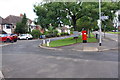
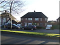
Comberford Road (A513) opposite Cedar Drive
The modern letter box has replaced a brick built pillar
Image: © Roger Templeman
Taken: 3 Aug 2017
0.16 miles
3
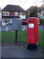
Elizabeth II postbox on Comberford Road, Tamworth
Postbox No. B79 1371.
Image: © JThomas
Taken: 25 Mar 2017
0.16 miles
4
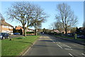
Comberford Road, Tamworth (A513)
Looking south east.
Image: © JThomas
Taken: 25 Mar 2017
0.16 miles
6
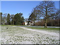
Wiggington Park.
A lovely crisp morning after a flurry of snow overnight.
Image: © alan marshall
Taken: 27 Feb 2004
0.20 miles