IMAGES TAKEN NEAR TO
Balfour, TAMWORTH, B79 7BH
Introduction
This page details the photographs taken nearby to Balfour, B79 7BH by members of the Geograph project.
The Geograph project started in 2005 with the aim of publishing, organising and preserving representative images for every square kilometre of Great Britain, Ireland and the Isle of Man.

There are currently over 7.5m images from over14,400 individuals and you can help contribute to the project by visiting https://www.geograph.org.uk
Image Map
Images are licensed for reuse under creativecommons.org/licenses/by-sa/2.0
Notes
- Clicking on the map will re-center to the selected point.
- The higher the marker number, the further away the image location is from the centre of the postcode.
Image Listing (435 Images Found)
Images are licensed for reuse under creativecommons.org/licenses/by-sa/2.0
Image
Details
Distance
2
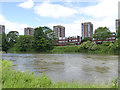
Tower blocks at Tamworth
Part of the expansion of Tamworth as a dormitory town for Birmingham.
Image: © Alan Murray-Rust
Taken: 5 Jun 2014
0.03 miles
5
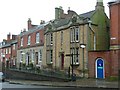
Bank House, Lady Bank, Tamworth
Formerly Tamworth Savings Bank, this Tudor-Gothic style building dates from 1848 and was built to house the bank founded by Sir Robert Peel in 1823. Link for Heritage Trail leaflet (PDF) http://www.tamworth.gov.uk/PDF/heritage_trail2.pdf
Image: © Humphrey Bolton
Taken: 13 Nov 2009
0.04 miles
6
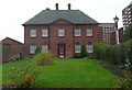
Brewery House, Lady Bank, Tamworth
Now an annex to the Castle Hotel, the old Brewery House was donated to the town by Lord Weymouth and Lord Middleton as a workhouse in 1750. It gained its name when it was later purchased by local businessman Edward Morgan, who owned a brewery to the rear of the property. Link for Heritage Trail leaflet (PDF) http://www.tamworth.gov.uk/PDF/heritage_trail2.pdf
Image: © Humphrey Bolton
Taken: 13 Nov 2009
0.04 miles
7
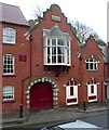
Castle Hotel extension, Hollow Way, Tamworth
Dated 1900, and in the eclectic style of the period.
Image: © Humphrey Bolton
Taken: 13 Nov 2009
0.04 miles
8
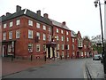
Castle Hotel, Hollow Way, Tamworth
On the cornerwith Marhet Street. Dating back to the 19th Century, the building has been used for numerous purposes and been extended many times since.
Image: © Humphrey Bolton
Taken: 13 Nov 2009
0.04 miles
9
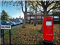
Postbox at Tamworth
B79 1388. Royal Mail list this box as 'Balfour'.
Image: © David Bremner
Taken: 4 Nov 2022
0.05 miles
10
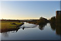
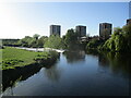
River Tame west again - Tamworth, Staffordshire
This view was taken looking westwards over the River Tame from Lady Bridge, which crosses the river on the south side of the town of Tamworth. On the right the River Tame and mid-photo the Flood Relief Channel. An application has been put in, reports the Tamworth Herald (16 Jan 2020) for the building of 141 homes at Coton Image and the demolition of Coton House Farm. The site has been approved in the local plan for 77 homes, with understandable reluctance by local residents. Further developments - no pun intended - are awaited. Time photo taken 3.38 pm GMT (Greenwich Mean Time).
Image]
Image: © Martin Richard Phelan
Taken: 20 Jan 2020
0.05 miles