IMAGES TAKEN NEAR TO
Waverton Avenue, TAMWORTH, B79 0HJ
Introduction
This page details the photographs taken nearby to Waverton Avenue, B79 0HJ by members of the Geograph project.
The Geograph project started in 2005 with the aim of publishing, organising and preserving representative images for every square kilometre of Great Britain, Ireland and the Isle of Man.

There are currently over 7.5m images from over14,400 individuals and you can help contribute to the project by visiting https://www.geograph.org.uk
Image Map
Images are licensed for reuse under creativecommons.org/licenses/by-sa/2.0
Notes
- Clicking on the map will re-center to the selected point.
- The higher the marker number, the further away the image location is from the centre of the postcode.
Image Listing (18 Images Found)
Images are licensed for reuse under creativecommons.org/licenses/by-sa/2.0
Image
Details
Distance
2
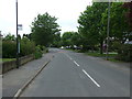
Spring colour
Some spring colour beginning to appear in the trees in Warton.
Image: © cris sloan
Taken: 8 Apr 2007
0.14 miles
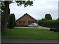
3
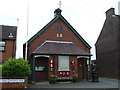
Warton Parish Room and War Memorial
Local village hall built 1909.
Image: © JThomas
Taken: 23 May 2015
0.14 miles

6
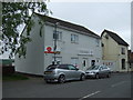
Post Office and shop, Warton
On Maypole Road.
Image: © JThomas
Taken: 23 May 2015
0.16 miles
8
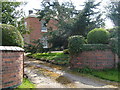
Living in a dream
Lucky people, living in this beautiful house. The Elms, Warton
Image: © cris sloan
Taken: 8 Apr 2007
0.16 miles