IMAGES TAKEN NEAR TO
Coventry Road, TAMWORTH, B78 2LW
Introduction
This page details the photographs taken nearby to Coventry Road, B78 2LW by members of the Geograph project.
The Geograph project started in 2005 with the aim of publishing, organising and preserving representative images for every square kilometre of Great Britain, Ireland and the Isle of Man.

There are currently over 7.5m images from over14,400 individuals and you can help contribute to the project by visiting https://www.geograph.org.uk
Image Map
Images are licensed for reuse under creativecommons.org/licenses/by-sa/2.0
Notes
- Clicking on the map will re-center to the selected point.
- The higher the marker number, the further away the image location is from the centre of the postcode.
Image Listing (30 Images Found)
Images are licensed for reuse under creativecommons.org/licenses/by-sa/2.0
Image
Details
Distance
1
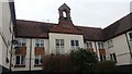
Former School, Kingsbury
Board School converted to homes/flats on Church Lane, Kingsbury
Image: © Michael Westley
Taken: 24 Mar 2018
0.07 miles
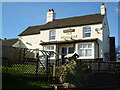
2
The White Swan
On the A51 Tamworth Road in Kingsbury.
Image: © Carl Baker
Taken: 7 Nov 2006
0.07 miles
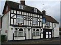
3
Teachers House, Kingsbury
The core of this fine house dates from the late 17th century, although its exterior appearance is more recent (late 18th/early 19th maybe, suggesting alterations around that time) and it was Grade II listed https://britishlistedbuildings.co.uk/101319910-teachers-house-kingsbury & https://historicengland.org.uk/listing/the-list/list-entry/1319910?section=official-list-entry in 1953. The adjacent building, offshot to the right Image was formerly a school and this was the head-master's house.
Image: © Richard Law
Taken: 6 Apr 2023
0.08 miles
4
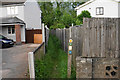
The Heart of England Way at Kingsbury
A narrow path between the houses leading to Kingsbury Meadow.
Image: © Bill Boaden
Taken: 25 May 2019
0.09 miles
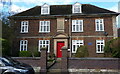
5
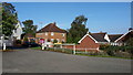
Houses in Church Lane
Houses in a quiet cul-de-sac in Kingsbury.
Image: © Peter Mackenzie
Taken: 16 Oct 2017
0.10 miles
6
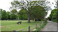
Open space near Kingsbury Church
View from footpath and track leading to entrance of Kingsbury Water Park, there is a large open grass area with seating for general use.
Image: © Michael Westley
Taken: 16 May 2010
0.12 miles
7
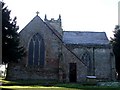
SS Peter & Paul, Kingsbury - East End
This is a view of the eastern end of Image], looking therefore at the east window of the chancel. The door immediately to the right is to the boiler room which was the old vestry, the vestry now being in the Bracebridge Chapel which occupies most of the north transept seen sticking out to the right here.
Plan of church - http://www.british-history.ac.uk/image.aspx?compid=42664&filename=fig86.gif&pubid=286
Image: © Rob Farrow
Taken: 7 Dec 2008
0.13 miles
8
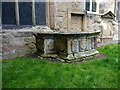
Chest tomb for 2 generations of the Brabson family
An unusual L-shaped, double chest-tomb, dated 1722 and 1740, for a mother and daughter both called Anne Brabson. It was Grade II listed https://britishlistedbuildings.co.uk/101319941-chest-tomb-in-angle-between-chancel-and-south-aisle-of-church-of-saints-peter-and-st-paul-kingsbury & https://historicengland.org.uk/listing/the-list/list-entry/1319941?section=official-list-entry in 1988.
Image: © Richard Law
Taken: 6 Apr 2023
0.13 miles
9
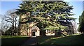
St Peter & St Paul's Church, Kingsbury
Kingsbury's fine old church dates back to the C12th with numerous additions over the centuries. It stands in an attractive churchyard next to the ancient Image The only trouble with the many sturdy trees in the grounds is that they make taking a full side-on view of the church almost impossible - this being the best I could do. For more information on the church, see http://www.british-history.ac.uk/report.aspx?compid=42664#s4
Image: © Rob Farrow
Taken: 7 Dec 2008
0.13 miles