IMAGES TAKEN NEAR TO
Abbey View, TAMWORTH, B78 1NP
Introduction
This page details the photographs taken nearby to Abbey View, B78 1NP by members of the Geograph project.
The Geograph project started in 2005 with the aim of publishing, organising and preserving representative images for every square kilometre of Great Britain, Ireland and the Isle of Man.

There are currently over 7.5m images from over14,400 individuals and you can help contribute to the project by visiting https://www.geograph.org.uk
Image Map
Images are licensed for reuse under creativecommons.org/licenses/by-sa/2.0
Notes
- Clicking on the map will re-center to the selected point.
- The higher the marker number, the further away the image location is from the centre of the postcode.
Image Listing (34 Images Found)
Images are licensed for reuse under creativecommons.org/licenses/by-sa/2.0
Image
Details
Distance
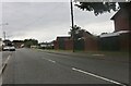
1
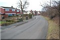
St Helena Road
Looking towards the B5000 junction
Image: © Pete Freeman
Taken: 13 Feb 2007
0.06 miles
3
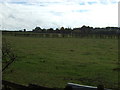
Grazing near Polesworth
South of Grendon Road.
Image: © JThomas
Taken: 2 Nov 2013
0.12 miles
4
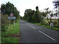
Grendon Road (B5000)
Heading east leaving Polesworth.
Image: © JThomas
Taken: 2 Nov 2013
0.14 miles
7
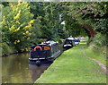
Narrowboats moored along the Coventry Canal
This stretch of the canal is between bridges 50b and 51.
Image: © Mat Fascione
Taken: 13 Sep 2015
0.18 miles

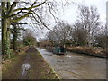
10
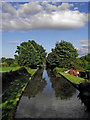
Coventry Canal east of Polesworth in Warwickshire
This is the Coventry Canal, looking east from Limekiln Bridge, No 51.
Jo Turner writes:
Image: © Roger D Kidd
Taken: 18 Aug 2013
0.19 miles