IMAGES TAKEN NEAR TO
The Lair, TAMWORTH, B78 1BA
Introduction
This page details the photographs taken nearby to The Lair, B78 1BA by members of the Geograph project.
The Geograph project started in 2005 with the aim of publishing, organising and preserving representative images for every square kilometre of Great Britain, Ireland and the Isle of Man.

There are currently over 7.5m images from over14,400 individuals and you can help contribute to the project by visiting https://www.geograph.org.uk
Image Map
Images are licensed for reuse under creativecommons.org/licenses/by-sa/2.0
Notes
- Clicking on the map will re-center to the selected point.
- The higher the marker number, the further away the image location is from the centre of the postcode.
Image Listing (10 Images Found)
Images are licensed for reuse under creativecommons.org/licenses/by-sa/2.0
Image
Details
Distance
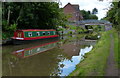
1
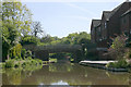
The Coventry Canal
As it passes through Polesworth
Image: © Neil Geering
Taken: 15 May 2005
0.17 miles

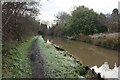
3
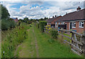
Bungalows next to the Coventry Canal, Polesworth
Image: © Mat Fascione
Taken: 13 Sep 2015
0.22 miles
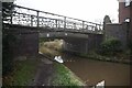

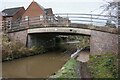
6
Mill Bridge
Coventry Canal bridge no. 53. The road leading South out of Polesworth towards Dordon.
Image: © Robert Eva
Taken: 25 Oct 2016
0.22 miles
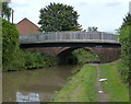
8
Mill Bridge No 53 in Polesworth
The bridge carries Market Street across the Coventry Canal.
Image: © Mat Fascione
Taken: 13 Sep 2015
0.23 miles
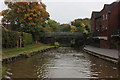
10
Polesworth Bridge No 54 and footbridge
The bridge carries the B5000 Tamworth Road across the Coventry Canal in Polesworth.
Image: © Mat Fascione
Taken: 13 Sep 2015
0.25 miles