IMAGES TAKEN NEAR TO
Valley Lane, TAMWORTH, B77 5BE
Introduction
This page details the photographs taken nearby to Valley Lane, B77 5BE by members of the Geograph project.
The Geograph project started in 2005 with the aim of publishing, organising and preserving representative images for every square kilometre of Great Britain, Ireland and the Isle of Man.

There are currently over 7.5m images from over14,400 individuals and you can help contribute to the project by visiting https://www.geograph.org.uk
Image Map
Images are licensed for reuse under creativecommons.org/licenses/by-sa/2.0
Notes
- Clicking on the map will re-center to the selected point.
- The higher the marker number, the further away the image location is from the centre of the postcode.
Image Listing (36 Images Found)
Images are licensed for reuse under creativecommons.org/licenses/by-sa/2.0
Image
Details
Distance
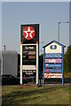
1
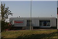
Tippers, Builders Merchant (1)
The above photograph shows a view of Tippers builders merchants. This photograph Image shows a view next to Tippers
Image: © Chris' Buet
Taken: 9 Sep 2009
0.08 miles
2
Brent (2)
The above photograph is similar to this one Image but the above photograph was taken with the use of a zoom.
Image: © Chris' Buet
Taken: 9 Sep 2009
0.09 miles
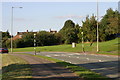
3
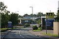
A.T.S. - Euromaster, Tyre Fitter outlet
This photograph Image shows a view of the road that goes passed the above A.T.S - Euromaster outlet.
Image: © Chris' Buet
Taken: 9 Sep 2009
0.09 miles
5
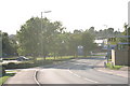
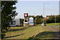
Ninian Way, Signs
This photograph shows a view of a group of signs located next to Ninian Way. The location of these signs can be seen in a wider context in this photograph Image
Image: © Chris' Buet
Taken: 9 Sep 2009
0.13 miles
6
Ninian Way, Zebra Crossing
This photograph Image shows an area next to this Zebra crossing, part of the Zebra crossing can be seen on the far right handside of the photograph.
Image: © Chris' Buet
Taken: 9 Sep 2009
0.13 miles
7
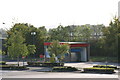
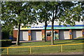
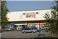
Car Wash, located at the CO-OP Superstore
This photograph Image shows a view the CO-OP Superstore, where this car wash is located.
Image: © Chris' Buet
Taken: 9 Sep 2009
0.13 miles
8
CO-OP Superstore, Car park
This photograph Image shows another view of this superstore.
Image: © Chris' Buet
Taken: 9 Sep 2009
0.14 miles
9
Open Grassy area next to Ninian Way (2)
This photograph Image shows another open grassy area next to Ninian Way.
Image: © Chris' Buet
Taken: 9 Sep 2009
0.14 miles
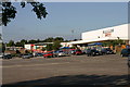
10
CO-OP Superstore (3)
This photograph Image shows another view of this superstore.
Image: © Chris' Buet
Taken: 9 Sep 2009
0.15 miles