IMAGES TAKEN NEAR TO
Correen, TAMWORTH, B77 4JS
Introduction
This page details the photographs taken nearby to Correen, B77 4JS by members of the Geograph project.
The Geograph project started in 2005 with the aim of publishing, organising and preserving representative images for every square kilometre of Great Britain, Ireland and the Isle of Man.

There are currently over 7.5m images from over14,400 individuals and you can help contribute to the project by visiting https://www.geograph.org.uk
Image Map
Images are licensed for reuse under creativecommons.org/licenses/by-sa/2.0
Notes
- Clicking on the map will re-center to the selected point.
- The higher the marker number, the further away the image location is from the centre of the postcode.
Image Listing (21 Images Found)
Images are licensed for reuse under creativecommons.org/licenses/by-sa/2.0
Image
Details
Distance
1
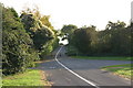
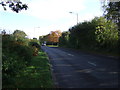
A Pathway located along the B5000
This above photograph shows a view of a pathway leading away from the side of the B5000 towards Stonydelph. This photograph Image shows a view of what is located to the right handside of the above photograph.
Image: © Chris' Buet
Taken: 1 Oct 2009
0.03 miles
2
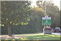
Tamworth, Staffordshire Town Sign (1)
The above photograph shows two signs announcing to any traveller travelling along this part of the B5000 that they are entering Tamworth, a town in the county of Staffordshire. This photograph Image shows the above town sign from further away.
Image: © Chris' Buet
Taken: 1 Oct 2009
0.04 miles
3
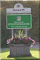
Tamworth, Staffordshire Town Sign (2)
This photograph shows a close up view of the Town sign in this photograph Image
Image: © Chris' Buet
Taken: 1 Oct 2009
0.06 miles
4
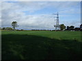
Farmland and pylon
North of Glascote Road (B5000).
Image: © JThomas
Taken: 2 Nov 2013
0.13 miles
5
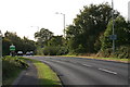
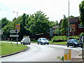
Glascote Road (B5000)
Heading east towards Polesworth.
Image: © JThomas
Taken: 2 Nov 2013
0.13 miles
6
A View of the B5000 (21)
This photograph Image shows another view of the B5000.
Image: © Chris' Buet
Taken: 29 May 2009
0.18 miles
7
A view of the B5000 (23)
This photograph Image shows another view of another part of the B5000.
Image: © Chris' Buet
Taken: 1 Oct 2009
0.20 miles
8
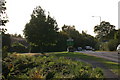
A View of the B5000 (24)
The above photograph shows a view of the B5000 passing an area of greenery next to it. This photograph Image shows another view of the B5000.
Image: © Chris' Buet
Taken: 1 Oct 2009
0.21 miles
9
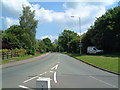
A View of one of the B5000 Traffic Islands (15)
This photograph Image shows another view of the above traffic island. The road that stretches into the distance in the above photograph is part of Sandy Way.
Image: © Chris' Buet
Taken: 29 May 2009
0.21 miles
10
Pennine Way (1)
The above photograph shows one end of Pennine Way, as it enters Stoneydelph.
Image: © Chris' Buet
Taken: 29 May 2009
0.22 miles