IMAGES TAKEN NEAR TO
Crossfell, TAMWORTH, B77 4HQ
Introduction
This page details the photographs taken nearby to Crossfell, B77 4HQ by members of the Geograph project.
The Geograph project started in 2005 with the aim of publishing, organising and preserving representative images for every square kilometre of Great Britain, Ireland and the Isle of Man.

There are currently over 7.5m images from over14,400 individuals and you can help contribute to the project by visiting https://www.geograph.org.uk
Image Map
Images are licensed for reuse under creativecommons.org/licenses/by-sa/2.0
Notes
- Clicking on the map will re-center to the selected point.
- The higher the marker number, the further away the image location is from the centre of the postcode.
Image Listing (12 Images Found)
Images are licensed for reuse under creativecommons.org/licenses/by-sa/2.0
Image
Details
Distance
1
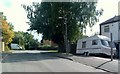
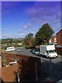
Garrigill, Tamworth
Looking generally away from the junction with Fossdale road.
Image: © John Carver
Taken: 24 Sep 2007
0.13 miles
2
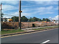
Sandy Way - Development
The junction between the B5000 and Sandy Way, Amington.
Building development clearly taking place.
Image: © John Carver
Taken: 24 Sep 2007
0.13 miles
3
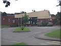
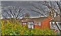
Stoneydelph Primary School
This estate is so densely packed with houses that this school is only a short distance from another primary school.
Image: © Angella Streluk
Taken: 27 Aug 2005
0.13 miles
4
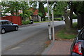
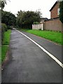
Garrigill - viewed along the road
Photograph of Garrigill in Tamworth. Fossdale Road is to the left of camera.
Image: © John Carver
Taken: 6 May 2009
0.16 miles
5
Garrigill Tamworth
Plenty of green life within the area, not just bricks and mortar
Image: © John Carver
Taken: 5 Apr 2010
0.16 miles
6
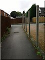
Garrigill and Footpath
The foot and path leading to the roadway of Garrigill, turn left at the end heading in the general direction of Fossdale Road.
Image: © John Carver
Taken: 12 Sep 2008
0.17 miles
7
Garrigill leading from Fossdale Road, Tamworth
Pictured in Garrigill looking generally towards the primary school on Fossdale Road
Image: © John Carver
Taken: 23 Sep 2007
0.20 miles
8
Foot and Cycle Path
The foot and cycle path leading from Garrigill, heading in the general direction of Fossdale Road.
Image: © John Carver
Taken: 12 Sep 2008
0.23 miles
9
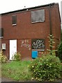
Empty House
Empty house for sale, along the foot and cycle path leading from Garrigill, heading in the general direction of Fossdale Road.
Image: © John Carver
Taken: 12 Sep 2008
0.23 miles
10
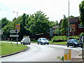
Pennine Way (1)
The above photograph shows one end of Pennine Way, as it enters Stoneydelph.
Image: © Chris' Buet
Taken: 29 May 2009
0.24 miles