IMAGES TAKEN NEAR TO
Madrona, TAMWORTH, B77 4EJ
Introduction
This page details the photographs taken nearby to Madrona, B77 4EJ by members of the Geograph project.
The Geograph project started in 2005 with the aim of publishing, organising and preserving representative images for every square kilometre of Great Britain, Ireland and the Isle of Man.

There are currently over 7.5m images from over14,400 individuals and you can help contribute to the project by visiting https://www.geograph.org.uk
Image Map
Images are licensed for reuse under creativecommons.org/licenses/by-sa/2.0
Notes
- Clicking on the map will re-center to the selected point.
- The higher the marker number, the further away the image location is from the centre of the postcode.
Image Listing (4 Images Found)
Images are licensed for reuse under creativecommons.org/licenses/by-sa/2.0
Image
Details
Distance
1
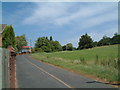
A pathway going past Foxglove (1)
The pathway shown in this photograph, is the same as this one Image but taken from a different location.
Image: © Chris' Buet
Taken: 1 Jul 2008
0.18 miles
2
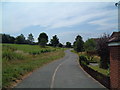
A pathway going past Foxglove (2)
This photograph was taken from the same spot as this one Image
Image: © Chris' Buet
Taken: 1 Jul 2008
0.21 miles
3
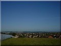
View of Tamworth from Amington Heath
This view is from the second highest point in Tamworth. The castle can just be made out to the right of the flats. The housing nearby is built on land formerly used by Gibbs and Canning Limited terracotta works.
Image: © Angella Streluk
Taken: Unknown
0.22 miles
4

Amington Heath Community School
This school is at the centre of a large housing estate. This area was formerly a mining and farming area.
Image: © Angella Streluk
Taken: 27 Aug 2005
0.22 miles