IMAGES TAKEN NEAR TO
Mica Close, TAMWORTH, B77 4DR
Introduction
This page details the photographs taken nearby to Mica Close, B77 4DR by members of the Geograph project.
The Geograph project started in 2005 with the aim of publishing, organising and preserving representative images for every square kilometre of Great Britain, Ireland and the Isle of Man.

There are currently over 7.5m images from over14,400 individuals and you can help contribute to the project by visiting https://www.geograph.org.uk
Image Map
Images are licensed for reuse under creativecommons.org/licenses/by-sa/2.0
Notes
- Clicking on the map will re-center to the selected point.
- The higher the marker number, the further away the image location is from the centre of the postcode.
Image Listing (25 Images Found)
Images are licensed for reuse under creativecommons.org/licenses/by-sa/2.0
Image
Details
Distance
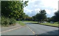
1
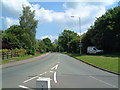
A View of the B5000 (21)
This photograph Image shows another view of the B5000.
Image: © Chris' Buet
Taken: 29 May 2009
0.08 miles
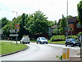
2
A View of one of the B5000 Traffic Islands (15)
This photograph Image shows another view of the above traffic island. The road that stretches into the distance in the above photograph is part of Sandy Way.
Image: © Chris' Buet
Taken: 29 May 2009
0.09 miles

4
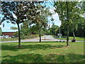
Sandy Way (7)
This photograph Image shows another part of Sandy Way.
Image: © Chris' Buet
Taken: 29 May 2009
0.11 miles
5
A View of the B5000 (20)
This photograph Image shows another view of the B5000, approaching a traffic island.
Image: © Chris' Buet
Taken: 29 May 2009
0.12 miles
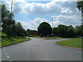
6
A View of one of the B5000 Traffic Islands (13)
This photograph Image shows another view of this traffic island.
Image: © Chris' Buet
Taken: 29 May 2009
0.12 miles
7
A View of one of the B5000 Traffic Islands (16)
This photograph Image shows another view of this traffic island. The road to the left in the above photograph, can be seen in this photograph Image
Image: © Chris' Buet
Taken: 29 May 2009
0.12 miles
8
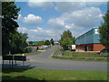
From layby on B5000
From a layby on B5000 looking in the general direction of Polesworth.
Traffic island ahead.
Turn right at island for Stoneydelph.
Turn left for Amington industrial estate.
Image: © John Carver
Taken: 24 Sep 2007
0.13 miles
9
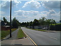
Pennine Way (1)
The above photograph shows one end of Pennine Way, as it enters Stoneydelph.
Image: © Chris' Buet
Taken: 29 May 2009
0.13 miles
10

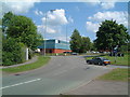
A View of one of the B5000 Traffic Islands (11)
The above traffic island is situated between, Sandy Way, Pennine Way and the B5000. This photograph Image shows a view of the B5000.
Image: © Chris' Buet
Taken: 29 May 2009
0.14 miles