IMAGES TAKEN NEAR TO
Arion Close, TAMWORTH, B77 3NS
Introduction
This page details the photographs taken nearby to Arion Close, B77 3NS by members of the Geograph project.
The Geograph project started in 2005 with the aim of publishing, organising and preserving representative images for every square kilometre of Great Britain, Ireland and the Isle of Man.

There are currently over 7.5m images from over14,400 individuals and you can help contribute to the project by visiting https://www.geograph.org.uk
Image Map
Images are licensed for reuse under creativecommons.org/licenses/by-sa/2.0
Notes
- Clicking on the map will re-center to the selected point.
- The higher the marker number, the further away the image location is from the centre of the postcode.
Image Listing (17 Images Found)
Images are licensed for reuse under creativecommons.org/licenses/by-sa/2.0
Image
Details
Distance
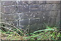
1
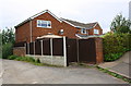
Moor Lane track heading northeast past #9 Arion Close
Ordnance Survey records indicate that in 1964 a benchmark levelled at 61.746m above Newlyn Datum was verified on a wall angle where a new wall meets a wooden gate.
Image: © Roger Templeman
Taken: 29 Aug 2017
0.02 miles
2
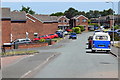
Marlow Road residential housing
Private residential homes constructed around 1965.
Image: © John Carver
Taken: 24 Jun 2018
0.03 miles
3
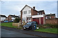
1965 housing Redwell Close in Tamworth
A semi-detached house in Redwell Close, Tamworth. Typical style of 1965 house construction for the immediate area.
Image: © John Carver
Taken: 3 Dec 2017
0.07 miles
4
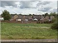
Jason Close, Tamworth
From the railway.
Image: © Andrew Abbott
Taken: 5 Jun 2019
0.08 miles
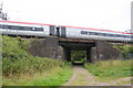
5
Benchmark on railway bridge over track east of Tamworth Station
Ordnance Survey cut mark benchmark described on the Bench Mark Database at www.bench-marks.org.uk/bm88440
Image: © Roger Templeman
Taken: 29 Aug 2017
0.09 miles
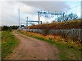
7
Train heading towards Tamworth Station on Bridge UB77 LEC2
There is an Ordnance Survey benchmark Image on the near end of the bridge wall on the right hand side of the track
Image: © Roger Templeman
Taken: 29 Aug 2017
0.12 miles
9
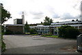
Ankermoor Primary School
This school is named after the River Anker which runs close by.
Image: © Angella Streluk
Taken: 27 Aug 2005
0.18 miles
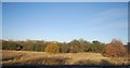
10
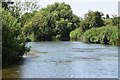
Bolehall Warwickshire Moors
Standing on the eroded river bank.
Image: © John Carver
Taken: 24 Jun 2018
0.19 miles