IMAGES TAKEN NEAR TO
Ridgewood Rise, TAMWORTH, B77 3AQ
Introduction
This page details the photographs taken nearby to Ridgewood Rise, B77 3AQ by members of the Geograph project.
The Geograph project started in 2005 with the aim of publishing, organising and preserving representative images for every square kilometre of Great Britain, Ireland and the Isle of Man.

There are currently over 7.5m images from over14,400 individuals and you can help contribute to the project by visiting https://www.geograph.org.uk
Image Map
Images are licensed for reuse under creativecommons.org/licenses/by-sa/2.0
Notes
- Clicking on the map will re-center to the selected point.
- The higher the marker number, the further away the image location is from the centre of the postcode.
Image Listing (75 Images Found)
Images are licensed for reuse under creativecommons.org/licenses/by-sa/2.0
Image
Details
Distance
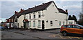
1
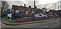
Old School, Tamworth Road, Amington
The school has been converted into residential units forming a housing project.
Image: © Paul Collins
Taken: 27 Nov 2020
0.09 miles
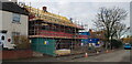
4
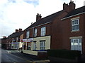
Liberal House Inn, Amington
At the time of photographing, public houses are more or less closed, it being the second national lockdown during the Coronavirus pandemic.
Image: © Paul Collins
Taken: 27 Nov 2020
0.10 miles
7

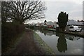
Coventry Canal Bridge No 67 at Amington, Staffordshire
Edit: The former accommodation bridge carries no public right of way across it, and is now redundant. The narrow strip of land (off to the left) leading to Tamworth Road has now (2023) been built on with a new private residence.
Image: © Roger D Kidd
Taken: 11 Jun 2008
0.11 miles
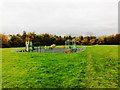
9

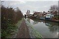
Coventry Canal near Amington in Staffordshire
Looking north-east through the arch of Bridge No 67. Off to the left is a pleasant area of park land. Off to the right is housing by Tamworth Road. Bridge No 67 was an accommodation bridge linking Tamworth Road with fields to the left. As I write (2023), the narrow strip of land between the canal and Tamworth Road has appeared disused, but new images show that a house has been built, completely blocking off any future reopening of the path to the canal.
Bridges 65 to 70 in Amington are all Grade II listed.
Image: © Roger Kidd
Taken: 21 Sep 2016
0.11 miles
10

Bridge No 67 on the Coventry Canal
In the Amington area of Tamworth.
Image: © Mat Fascione
Taken: 13 Sep 2015
0.11 miles