IMAGES TAKEN NEAR TO
Holsworth Close, TAMWORTH, B77 2JD
Introduction
This page details the photographs taken nearby to Holsworth Close, B77 2JD by members of the Geograph project.
The Geograph project started in 2005 with the aim of publishing, organising and preserving representative images for every square kilometre of Great Britain, Ireland and the Isle of Man.

There are currently over 7.5m images from over14,400 individuals and you can help contribute to the project by visiting https://www.geograph.org.uk
Image Map
Images are licensed for reuse under creativecommons.org/licenses/by-sa/2.0
Notes
- Clicking on the map will re-center to the selected point.
- The higher the marker number, the further away the image location is from the centre of the postcode.
Image Listing (5 Images Found)
Images are licensed for reuse under creativecommons.org/licenses/by-sa/2.0
Image
Details
Distance
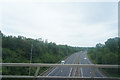
1

A5 Passing Underneath Railway, Kettlebrook, Tamworth
Image: © Roy Hughes
Taken: 20 Apr 2013
0.18 miles
2
Crossing over the A5
The railway line passes over the dual carriageway that is the A5.
Image: © Malcolm Neal
Taken: 8 Jul 2019
0.19 miles

4
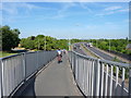
Ramp to the footbridge over the dualled A5
Mainly a pedestrian bridge, and fairly narrow to ride up, so we had to try, obviously. The access leads to the Image
Image: © Richard Law
Taken: 6 Jul 2018
0.24 miles
5
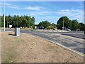
Roundabout on Tamworth Road
Situated in Mount Pleasant, this roundabout directs most northbound traffic off to the left, up Peeler's Way, and towards the inner Tamworth Ring Road. All other directions are mostly residential.
Image: © Richard Law
Taken: 6 Jul 2018
0.24 miles