IMAGES TAKEN NEAR TO
Bancroft, TAMWORTH, B77 2ET
Introduction
This page details the photographs taken nearby to Bancroft, B77 2ET by members of the Geograph project.
The Geograph project started in 2005 with the aim of publishing, organising and preserving representative images for every square kilometre of Great Britain, Ireland and the Isle of Man.

There are currently over 7.5m images from over14,400 individuals and you can help contribute to the project by visiting https://www.geograph.org.uk
Image Map
Images are licensed for reuse under creativecommons.org/licenses/by-sa/2.0
Notes
- Clicking on the map will re-center to the selected point.
- The higher the marker number, the further away the image location is from the centre of the postcode.
Image Listing (91 Images Found)
Images are licensed for reuse under creativecommons.org/licenses/by-sa/2.0
Image
Details
Distance
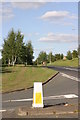
1
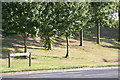
Marlborough Way (13)
The above photograph shows a group of trees located along a section of the Marlborough Way. This photograph Image shows another view of this road.
Image: © Chris' Buet
Taken: 20 Sep 2009
0.05 miles
2
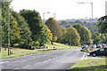
Marlborough Way (10)
The above photograph shows a section of the Marlborough Way, facing downhill. This photograph Image shows another of this road.
Image: © Chris' Buet
Taken: 20 Sep 2009
0.06 miles
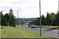
3
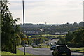
Marlborough Way (6)
The above photograph shows a section of the Marlborough Way, the photograph shows how steep the gradient of the Marlborough Way is, which can be deceptive to the drivers using it. The curve of the road can be seen more prominently from this photographs angle. This photograph shows another view of this road Image
Image: © Chris' Buet
Taken: 20 Sep 2009
0.06 miles
4
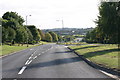
Marlborough Way (9)
The above photograph shows a downhill view of this road. This photograph Image shows another view of this road.
Image: © Chris' Buet
Taken: 20 Sep 2009
0.07 miles
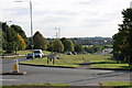
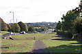
5
Leyland Road (2)
The two roads in the above photograph are Leyland Road and Marlborough Way. Leyland Road is the road in the foreground and the road stretching into the distance is Marlborough Way. This photograph Image shows another view of Leyland Road.
Image: © Chris' Buet
Taken: 20 Sep 2009
0.07 miles
6
Marlborough Way (11)
The above photograph shows a section of the Marlborough Way and Leyland road is the road seen across the photograph. This photograph Image shows another view of the Marlborough Way.
Image: © Chris' Buet
Taken: 20 Sep 2009
0.07 miles
7
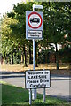
Welcome to Lakeside
This Road sign signifies that the driver or pedestrian is now entering an area of Tamworth known as Lakeside, the road behind the sign is called, Leyland Road. Which can also be seen in this photograph Image
Image: © Chris' Buet
Taken: 20 Sep 2009
0.08 miles
8
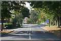
Leyland Road (1)
The above photograph shows a view of Leyland Road.
Image: © Chris' Buet
Taken: 20 Sep 2009
0.08 miles
9
Marlborough Way (5)
The above photograph shows a grassy area along a section of the Marlborough Way. This photograph Image shows another view of the Marlborough Way.
Image: © Chris' Buet
Taken: 20 Sep 2009
0.08 miles
10
A path located along Marlborough Way (1)
The above photograph shows a view of part of a path located along a section of the Marlborough Way. This photograph Image shows another view of Marlborough Way.
Image: © Chris' Buet
Taken: 20 Sep 2009
0.08 miles