IMAGES TAKEN NEAR TO
Carisbrooke, TAMWORTH, B77 2EP
Introduction
This page details the photographs taken nearby to Carisbrooke, B77 2EP by members of the Geograph project.
The Geograph project started in 2005 with the aim of publishing, organising and preserving representative images for every square kilometre of Great Britain, Ireland and the Isle of Man.

There are currently over 7.5m images from over14,400 individuals and you can help contribute to the project by visiting https://www.geograph.org.uk
Image Map
Images are licensed for reuse under creativecommons.org/licenses/by-sa/2.0
Notes
- Clicking on the map will re-center to the selected point.
- The higher the marker number, the further away the image location is from the centre of the postcode.
Image Listing (50 Images Found)
Images are licensed for reuse under creativecommons.org/licenses/by-sa/2.0
Image
Details
Distance
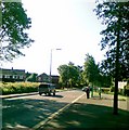
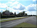
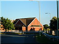
2
A view of the B5000 (9)
This photograph shows another view of the B5000. The building to my left handside out of view, is shown in this photograph Image
Image: © Chris' Buet
Taken: 15 Jun 2008
0.14 miles
3
A view of the B5000 (7)
This view shows the B5000 flowing in a North West direction and on the other side, in a South East direction the housing estate to my right handside, out of view contains the streets, Briar and Brookweed.
Image: © Chris' Buet
Taken: 15 Jun 2008
0.16 miles
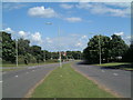
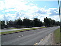
4

A view of the B5000 (5)
This photograph shows a view of the Northwest part of the B5000, the Northwest bound part of the B5000 is in the foreground. The Southeast bound part of the B5000 is in the background.
Image: © Chris' Buet
Taken: 15 Jun 2008
0.16 miles
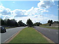
5
A view of the B5000 (1)
This photograph shows the Southeast bound part of the B5000 curving round after leaving the traffic island, which is also part of the B5000. This photograph was taken a bit further up from this photograph Image, but on a different day. The houses' in the background are situated in a street called Bancroft.
Image: © Chris' Buet
Taken: 1 Jul 2008
0.16 miles
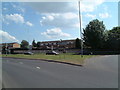
6
A view of the B5000 (10)
This photograph shows another view of the B5000, the road closest to me, heading into the distance is heading in a South East direction. The building to the right hand side of this photograph, out of view is shown in this photograph Image
Image: © Chris' Buet
Taken: 15 Jun 2008
0.17 miles
7
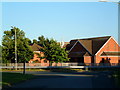
Sacred Heart Presbytery (3)
This photograph shows a view of Sacred Heart Presbytery, but from a slightly different angle than the others, I also used a Zoom to take this photograph. This photograph was taken not long after 8 p.m. which allowed me to use the nice evening sunset, to capture the nice red colour in the Presbytery's walls and the green in the trees next to it, and also the white colour of the Cross. The item in the centre of the White Cross is a piece of Wheat.
Image: © Chris' Buet
Taken: 10 Jun 2008
0.17 miles
8
A view of the B5000 (8)
This photograph shows another view of the B5000, from another angle. The building,out of view located behind the trees in the distance on the left handside of the photograph, is shown in this photograph Image but taken from a completely different location.
Image: © Chris' Buet
Taken: 15 Jun 2008
0.17 miles
9
A view of the B5000 (6)
This photograph shows a view of the B5000 from virtually the same spot as this photograph Image but with a slight change of angle. The Yellow lines in the foreground are part of one of the Bus stops along the B5000.
Image: © Chris' Buet
Taken: 15 Jun 2008
0.17 miles
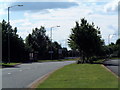
10
Sacred Heart Presbytery (2)
This is a closer shot of the Sacred Heart Presbytery, taken from the same location as this photograph Image but with the use of a Zoom. The start of Silver Link Road, can be seen to begin, where the white lines are in the centre of the photograph on the road, it then carries on between the Sacred Heart Presbytery and the trees' on the right hand side of the photograph. I was standing next to the Northwest bound part of the B5000, when this photograph was taken.
Image: © Chris' Buet
Taken: 10 Jun 2008
0.17 miles