IMAGES TAKEN NEAR TO
Nimbus, TAMWORTH, B77 1PW
Introduction
This page details the photographs taken nearby to Nimbus, B77 1PW by members of the Geograph project.
The Geograph project started in 2005 with the aim of publishing, organising and preserving representative images for every square kilometre of Great Britain, Ireland and the Isle of Man.

There are currently over 7.5m images from over14,400 individuals and you can help contribute to the project by visiting https://www.geograph.org.uk
Image Map
Images are licensed for reuse under creativecommons.org/licenses/by-sa/2.0
Notes
- Clicking on the map will re-center to the selected point.
- The higher the marker number, the further away the image location is from the centre of the postcode.
Image Listing (6 Images Found)
Images are licensed for reuse under creativecommons.org/licenses/by-sa/2.0
Image
Details
Distance
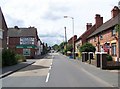
1
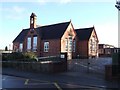
Dosthill School
A County Primary school catering for the 5 to 11 year-olds from the village of Dosthill.
The school was founded in 1887 under the Kingsbury school board. Dosthill was at that time in Warwickshire, but boundary changes placed Dosthill within the borough of Tamworth and so it was moved into Staffordshire. My father, P.D.H.Farrow, was headmaster of this school from 1965 until his retirement in 1979.
Image: © Rob Farrow
Taken: 26 Nov 2006
0.20 miles
2
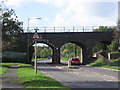
Railway Bridge, Dosthill
This bridge carries the Derby to Birmingham railway line. The road ahead leads to the junction with Tamworth Road, Dosthill.
Image: © Angella Streluk
Taken: 25 Oct 2005
0.21 miles
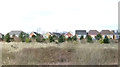
6
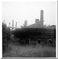
Pie Kilns : Photo 1
These "pie" kilns are long gone. I took this series of photos in about 1975 with a Black & White Polaroid camera hence the lack of quality, which has not been helped by their gradual degradation over time.
These kilns were off Rushy* Lane which ran from south of Dosthill up to the hamlet of Whateley, and were situated near to where that lane crossed the railway. They were used to fire industrial ceramics such as sewerage pipes which had been made in the nearby (and also long gone) Stoneware factory. There was considerable brick and pipe industry around this site up until the mid seventies, but these kilns had not been used for many years even then. I hope that there are higher quality photographs of these remarkable little examples of industrial heritage in existence somewhere, because I know of no examples of the actual kilns themselves anywhere these days.
*Rushy lane has subsequently lost its final "y" and is now known as Rush Lane. This is probably because on an early OS map the word "Rushy" was written along the route of the lane such that the "y" was round a corner. I think that on the next map this "y" was missed by the cartographer and so the lane got itself renamed.
Photos 2 & 3 : Image] Image]
Image: © Rob Farrow
Taken: Unknown
0.25 miles