IMAGES TAKEN NEAR TO
Kettlebrook Road, TAMWORTH, B77 1AB
Introduction
This page details the photographs taken nearby to Kettlebrook Road, B77 1AB by members of the Geograph project.
The Geograph project started in 2005 with the aim of publishing, organising and preserving representative images for every square kilometre of Great Britain, Ireland and the Isle of Man.

There are currently over 7.5m images from over14,400 individuals and you can help contribute to the project by visiting https://www.geograph.org.uk
Image Map
Images are licensed for reuse under creativecommons.org/licenses/by-sa/2.0
Notes
- Clicking on the map will re-center to the selected point.
- The higher the marker number, the further away the image location is from the centre of the postcode.
Image Listing (126 Images Found)
Images are licensed for reuse under creativecommons.org/licenses/by-sa/2.0
Image
Details
Distance
1
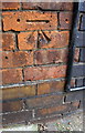
Benchmark on the north side of #57 Kettlebrook Road
Ordnance Survey cut mark benchmark described on the Bench Mark Database at www.bench-marks.org.uk/bm89188
Image: © Roger Templeman
Taken: 29 Aug 2017
0.05 miles
2
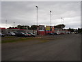
Tamworth F.C
Home of the ' Lambs ' Home game v AFC Wimbledon.
Image: © Anthony Vosper
Taken: 5 Sep 2009
0.05 miles
3

The Lamb Ground
The home of Tamworth FC, which plays in the Southern Premier League Central Division.
Image: © Bill Boaden
Taken: 13 Dec 2022
0.07 miles
4

Houses on the east side of Kettlebrook Road
There is an Ordnance Survey benchmark Image on the left hand side of the left hand house (#57) near its front corner
Image: © Roger Templeman
Taken: 29 Aug 2017
0.07 miles
5

Benchmark on Glascote Road railway bridge buttress
Ordnance Survey cut mark benchmark described on the Bench Mark Database at www.bench-marks.org.uk/bm89198
Image: © Roger Templeman
Taken: 29 Aug 2017
0.08 miles
6
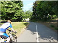
Shared footpath & cycleway in Tamworth
Seen here just outside the inner ring road, the pathway dives off to the right beyond the other two riders to go under the B5000 Glascote Road, and then heads into the parkland south of the river.
Image: © Richard Law
Taken: 6 Jul 2018
0.09 miles
7
Ankerdrive (18)
This photograph shows another view of Ankerdrive Image
Image: © Chris' Buet
Taken: 2 Jun 2009
0.09 miles
8
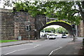
Railway bridge over Glascote Road (B5000)
There is an Ordnance Survey benchmark Image on the wide bridge buttress on the left hand side of the road, and right of the grey cabinet
Image: © Roger Templeman
Taken: 29 Aug 2017
0.10 miles
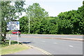
9
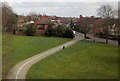
MacGregor Recreation Ground, Tamworth
A path crossing the southern side of the recreation ground meets Glascote Road, the B5000.
Image: © Derek Harper
Taken: 4 Apr 2013
0.10 miles
10
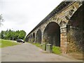
Tamworth, Kettlebrook Viaduct
Carrying Birmingham to Tamworth lines over River Anker and Glascote and Amington Roads; built 1839 by Robert Stephenson; listed by Historic England (as Bolehall Viaduct): http://www.imagesofengland.org.uk/Details/Default.aspx?id=386490&mode=adv
Image: © Mike Faherty
Taken: 18 Jun 2016
0.10 miles