IMAGES TAKEN NEAR TO
Wiggins Hill Road, SUTTON COLDFIELD, B76 9QE
Introduction
This page details the photographs taken nearby to Wiggins Hill Road, B76 9QE by members of the Geograph project.
The Geograph project started in 2005 with the aim of publishing, organising and preserving representative images for every square kilometre of Great Britain, Ireland and the Isle of Man.

There are currently over 7.5m images from over14,400 individuals and you can help contribute to the project by visiting https://www.geograph.org.uk
Image Map
Images are licensed for reuse under creativecommons.org/licenses/by-sa/2.0
Notes
- Clicking on the map will re-center to the selected point.
- The higher the marker number, the further away the image location is from the centre of the postcode.
Image Listing (7 Images Found)
Images are licensed for reuse under creativecommons.org/licenses/by-sa/2.0
Image
Details
Distance
1
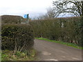
Permissive Path sign
Permissive path & Hempitt Cottage signs by Wiggins Hill Cottages in Wiggins Hill Road showing the start of the farm track leading east to Hempitt Cottage and footpaths giving access to Broad Balk Bridge and Wishaw Lane (east arm)
Image: © David Godfrey
Taken: 5 Feb 2011
0.03 miles
2
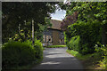
Wiggins Hill Farm
Vernacular farm building at Wiggins Hill Farm
Image: © P Gaskell
Taken: Unknown
0.15 miles
3
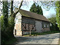
Barn, Wiggins Hill Road, Sutton Coldfield
Image: © Mike Beeson
Taken: 11 Apr 2007
0.16 miles
4
Wiggins Hill Farm
Just inside the Birmingham and West Midlands boundaries.
Image: © Christine Johnstone
Taken: 9 May 2022
0.21 miles
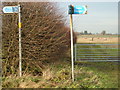
5

Permissive path signs
Permissive path signs at a cross path junction, providing access to: (1) left (north) through metal gate follow hedge then left (west) route to Wiggins Hill Cottages, (2) straight on (east) to Wishaw Lane (east arm) by the white cottage in background, (3) right (south) to Broad Balk Bridge and (4) back (west) another route to Wiggins Hill Cottages
Image: © David Godfrey
Taken: 8 Feb 2011
0.23 miles
6
Public footpath signs, near Curdworth
Providing directions to:(1) left (west) towards Wiggins Hill Cottages, Wiggins Hill Road, (2) straight on (north) through metal gate follow hedge then left (west) another route to Wiggins Hill Cottages, (3) right (east) Wishaw Lane, & (4) back (south) to Broad Balk Bridge and A4097 Kingsbury Road, near Curdworth.
Image: © David Godfrey
Taken: 4 Jan 2011
0.24 miles
7
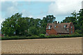
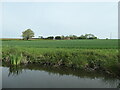
Cropfield and Wiggins Hill Farm near Curdworth, Warwickshire
This telephoto assisted image was taken from the Birmingham and Fazeley Canal shows Wiggins Hill Farm (17th century, Grade II listed).
Image: © Roger Kidd
Taken: 20 Aug 2012
0.25 miles