IMAGES TAKEN NEAR TO
Farthing Lane, SUTTON COLDFIELD, B76 9HF
Introduction
This page details the photographs taken nearby to Farthing Lane, B76 9HF by members of the Geograph project.
The Geograph project started in 2005 with the aim of publishing, organising and preserving representative images for every square kilometre of Great Britain, Ireland and the Isle of Man.

There are currently over 7.5m images from over14,400 individuals and you can help contribute to the project by visiting https://www.geograph.org.uk
Image Map
Images are licensed for reuse under creativecommons.org/licenses/by-sa/2.0
Notes
- Clicking on the map will re-center to the selected point.
- The higher the marker number, the further away the image location is from the centre of the postcode.
Image Listing (26 Images Found)
Images are licensed for reuse under creativecommons.org/licenses/by-sa/2.0
Image
Details
Distance
1
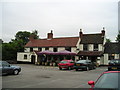
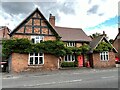
The Beehive Pub, Curdworth
Beehive Lane, Curdworth SUTTON COLDFIELD B76 9HG close to The Birmingham and Fazeley Canal Birmingham Canal Navigations (BCN)
Image: © canalandriversidepubs co uk
Taken: 18 Jun 2010
0.09 miles
2
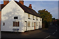
Cottages in Curdworth
A row of cottages on Coleshill Road, at the junction with Church Lane.
Image: © Stephen McKay
Taken: 21 Oct 2016
0.12 miles
3
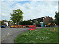
Roadworks, St Nicholas Walk, Curdworth
At the junction with Coleshill Road.
Image: © Christine Johnstone
Taken: 8 May 2022
0.15 miles
4
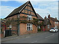
Red Lion Cottages, Coleshill Road, Curdworth
A house which has been divided into two cottages. Built in the early 1600s, with later alterations and additions. Grade II listed.
Image: © Christine Johnstone
Taken: 8 May 2022
0.16 miles
5
Red Lion Cottages, Curdworth
Grade II listed. Listing number 1365212. House, latterly divided into 2 cottages. Early 17th century with later alterations and additions. Timber-framed with brick infill panels and some brick rebuilding; plain tile roof; brick ridge stack.
Image: © Andrew Abbott
Taken: 15 Sep 2022
0.16 miles
6
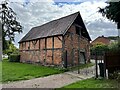
Historic barn in Curdworth
Grade II listed. Listing number 1299505. Late 17th century. Timber-framed with brick infill panels and some brick rebuilding; plain-tile roof. 3-bay range aligned north-west/south-east facing south-west.
Image: © Andrew Abbott
Taken: 15 Sep 2022
0.18 miles
7
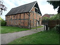
Barn, Coleshill Road, Curdworth
Formerly the Rectory barn. Listed Grade II and built in the late 1600s.
Image: © Christine Johnstone
Taken: 8 May 2022
0.18 miles
8
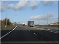
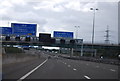
M42/ M6 (Toll) motorways divergence
The two lorries have just taken the M42 main line. Lanes for the M6 (Toll) are to their right while dedicated lanes for the A446 and A4097 are to the left. The four leftmost lanes rejoin for around a half-mile of 4-lane motorway before the lanes again diverge at what is now M42 junction 9.
Image: © Peter Whatley
Taken: 7 Dec 2011
0.18 miles
10
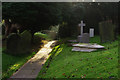
Curdworth Churchyard
Morning sun illuminates the path up to the church of St Nicholas and St Peter ad Vincula.
Image: © Stephen McKay
Taken: 21 Oct 2016
0.20 miles