IMAGES TAKEN NEAR TO
Glebe Fields, SUTTON COLDFIELD, B76 9ES
Introduction
This page details the photographs taken nearby to Glebe Fields, B76 9ES by members of the Geograph project.
The Geograph project started in 2005 with the aim of publishing, organising and preserving representative images for every square kilometre of Great Britain, Ireland and the Isle of Man.

There are currently over 7.5m images from over14,400 individuals and you can help contribute to the project by visiting https://www.geograph.org.uk
Image Map
Images are licensed for reuse under creativecommons.org/licenses/by-sa/2.0
Notes
- Clicking on the map will re-center to the selected point.
- The higher the marker number, the further away the image location is from the centre of the postcode.
Image Listing (77 Images Found)
Images are licensed for reuse under creativecommons.org/licenses/by-sa/2.0
Image
Details
Distance
1
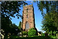
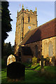
Church of St Nicholas and St Peter ad Vincula, Curdworth
Image: © David Martin
Taken: 18 Jul 2016
0.05 miles
2
Curdworth: Ss Nicholas and Peter ad Vincula Church
Image: © Michael Garlick
Taken: 28 Apr 2016
0.05 miles
3
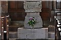
Curdworth: Ss Nicholas and Peter ad Vincula Church: The Norman font
The font has been cut down at some time as the head of the Lamb of God is missing.
Image: © Michael Garlick
Taken: 28 Apr 2016
0.05 miles
4
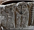
Curdworth: Ss Nicholas and Peter ad Vincula Church: The Norman font
Two of the Evangelists holding books
Image: © Michael Garlick
Taken: 28 Apr 2016
0.05 miles
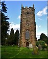
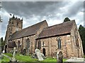
5
Curdworth Church
Dedicated to St Nicholas and St Peter ad Vincula, this church is of Norman origin although the tower is 15th century.
Image: © Stephen McKay
Taken: 21 Oct 2016
0.06 miles
6
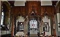
Curdworth: Ss Nicholas and Peter ad Vincula Church: Norman chancel arch
Image: © Michael Garlick
Taken: 28 Apr 2016
0.06 miles
7
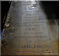
Curdworth: Ss Nicholas and Peter ad Vincula Church: Memorial to Dr. Samuel Johnson's mother
Image: © Michael Garlick
Taken: 28 Apr 2016
0.06 miles
8
Church of St Nicholas and St Peter, Curdworth
Grade II* listed. Listing number 1185754. Late 12th century, partially refenestrated in the early 14th century; a major addition was made in the late 15th century; restored in 1800 and 1895.
Image: © Andrew Abbott
Taken: 15 Sep 2022
0.06 miles
9
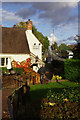
The White Horse, Curdworth
Part of the Vintage Inns chain, the White Horse faces busy Kingsbury Road on the edge of Curdworth village.
Image: © Stephen McKay
Taken: 17 Oct 2016
0.07 miles
10
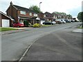
Houses on the south side of Glebefields, Curdworth
A residential development on the site of the village rectory and parish rooms. Curdworth is one of the first Anglo-Saxon settlements recorded in the Midlands. it was founded by the Mercian King Creoda in 585AD. Curdworth = Creoda's worth = Croaeda's enclosed settlement.
Image: © Christine Johnstone
Taken: 8 May 2022
0.07 miles