IMAGES TAKEN NEAR TO
Dunton Park, Kingsbury Road, SUTTON COLDFIELD, B76 9EB
Introduction
This page details the photographs taken nearby to Dunton Park, Kingsbury Road, B76 9EB by members of the Geograph project.
The Geograph project started in 2005 with the aim of publishing, organising and preserving representative images for every square kilometre of Great Britain, Ireland and the Isle of Man.

There are currently over 7.5m images from over14,400 individuals and you can help contribute to the project by visiting https://www.geograph.org.uk
Image Map
Images are licensed for reuse under creativecommons.org/licenses/by-sa/2.0
Notes
- Clicking on the map will re-center to the selected point.
- The higher the marker number, the further away the image location is from the centre of the postcode.
Image Listing (56 Images Found)
Images are licensed for reuse under creativecommons.org/licenses/by-sa/2.0
Image
Details
Distance
1
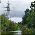
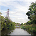
Birmingham and Fazeley Canal near Curdworth, Warwickshire
A telephoto assisted image, looking north-east towards Tamworth from near Curdworth Tunnel. About 350 metres ahead is Baylis's Bridge.
Image: © Roger Kidd
Taken: 30 Aug 2012
0.06 miles
2
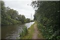
Birmingham & Fazeley Canal towards Baylis's Bridge
Image: © Ian S
Taken: 24 Jul 2021
0.09 miles
3
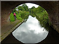
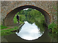
Canal at Baylis's Bridge near Curdworth, Warwickshire
This is the Birmingham and Fazeley Canal, looking south-west towards Minworth. Baylis's Bridge is an accommodation bridge which also carries a public footpath, already marked as such on Victorian maps.
Image: © Roger Kidd
Taken: 20 Aug 2012
0.09 miles
4
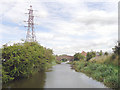
Birmingham and Fazeley Canal near Curdworth, Warwickshire
Looking north-east towards Tamworth from near Curdworth Tunnel.
Image: © Roger Kidd
Taken: 30 Aug 2012
0.10 miles
5
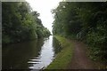
Birmingham and Fazeley Canal north of Curdworth, Warwickshire
This is the canal approaching Baylis's Bridge.
The original purpose of this canal was to provide a link between Birmingham and the south east of England, by way of the Coventry Canal and the Oxford Canal. John Smeaton was the engineer, and the canal was completed in 1789. The canal now runs from the BCN Main Line at Old Turn Junction, Birmingham to the Coventry Canal at Fazeley Junction, just outside Tamworth. The length is 15 miles (24 km), and it includes 38 locks. There is also a short branch to Digbeth, Birmingham. (Information from Wikipedia).
Image: © Roger D Kidd
Taken: 10 Sep 2008
0.10 miles
6
Canal north of Curdworth in Warwickshire
This is the Birmingham and Fazeley Canal, looking south-west towards Minworth. Baylis's Bridge is an accommodation bridge which also carries a public footpath, already marked as such on Victorian maps.
Image: © Roger Kidd
Taken: 20 Aug 2012
0.10 miles
7
Approaching Baylis's Bridge near Curdworth, Warwickshire
The original purpose of the Birmingham and Fazeley canal was to provide a link between Birmingham and the south east of England, by way of the Coventry Canal and the Oxford Canal. John Smeaton was the engineer, and the canal was completed in 1789. The canal now runs from the BCN Main Line at Old Turn Junction, Birmingham to the Coventry Canal at Fazeley Junction, just outside Tamworth. The length is 15 miles (24 km), and it includes 38 locks. There is also a short branch to Digbeth, Birmingham. (Information from Wikipedia).
Image: © Roger D Kidd
Taken: 10 Sep 2008
0.10 miles
8
Birmingham & Fazeley Canal towards Baylis's Bridge
Image: © Ian S
Taken: 24 Jul 2021
0.11 miles
9
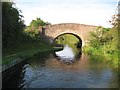
Birmingham & Fazeley Canal: Baylis's Bridge
Baylis's Bridge is a farm access bridge.
Image: © Nigel Cox
Taken: 9 Sep 2012
0.11 miles
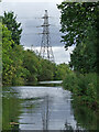
10
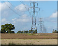
Pylons next to the Birmingham & Fazeley Canal
Image: © Mat Fascione
Taken: 27 Sep 2015
0.12 miles