IMAGES TAKEN NEAR TO
Monks Kirby Road, SUTTON COLDFIELD, B76 2UN
Introduction
This page details the photographs taken nearby to Monks Kirby Road, B76 2UN by members of the Geograph project.
The Geograph project started in 2005 with the aim of publishing, organising and preserving representative images for every square kilometre of Great Britain, Ireland and the Isle of Man.

There are currently over 7.5m images from over14,400 individuals and you can help contribute to the project by visiting https://www.geograph.org.uk
Image Map
Images are licensed for reuse under creativecommons.org/licenses/by-sa/2.0
Notes
- Clicking on the map will re-center to the selected point.
- The higher the marker number, the further away the image location is from the centre of the postcode.
Image Listing (14 Images Found)
Images are licensed for reuse under creativecommons.org/licenses/by-sa/2.0
Image
Details
Distance
1

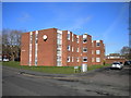
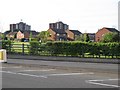
Flats on Monks Kirby Road
View of flats on suburban roads, north of Walmley
Image: © Michael Westley
Taken: 15 May 2010
0.02 miles
2
Charles Court, Walmley
A low rise block of flats off Berryfields Road.
Image: © Richard Vince
Taken: 2 Mar 2019
0.06 miles
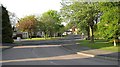
3
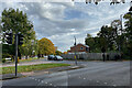
Berryfields Road joins Walmley Road, Sutton Coldfield
Not far to the east is open country, farmland!
Image: © Robin Stott
Taken: 19 Oct 2022
0.06 miles
4
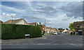
Walsh Drive, Reddicap Heath, Sutton Coldfield
Walsh Drive is one entry off Walmley Road to a residential estate south of Reddicap Heath Road.
Image: © Robin Stott
Taken: 19 Oct 2022
0.07 miles
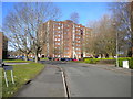
5

High rise flats, Berryfields Road
View from junction with Froggatts Ride, Sutton Coldfield
Image: © Michael Westley
Taken: 15 May 2010
0.12 miles
6
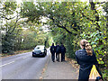
Going home on Walmley Road, Sutton Coldfield
A stretch of Walmley Road is confined by trees: single carriageway, no suburban road junctions. This is a continuation of The Belt, appearing on old maps as the strip of woodland along the presumed boundary of the New Hall estate.
Photo number 7452624.
Image: © Robin Stott
Taken: 19 Oct 2022
0.12 miles
7
Housing on Froggatts Ride, Sutton Coldfield
View from Thimble End Road, of housing on Froggatts Ride, and high rise flats on Berryfields Road
Image: © Michael Westley
Taken: 15 May 2010
0.14 miles
8
Suburbia, north Walmley, Sutton Coldfield
Evening view of Walsh Drive, near junction with Tysoe Drive
Image: © Michael Westley
Taken: 15 May 2010
0.16 miles
9
Berryfields Road, Walmley
With Elizabeth House up ahead.
Image: © Richard Vince
Taken: 2 Mar 2019
0.16 miles
10
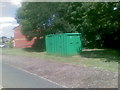
Public toilet, Dovebridge Close, Reddicap Heath
Image: © Alex McGregor
Taken: 20 Jun 2011
0.17 miles