IMAGES TAKEN NEAR TO
Ullenhall Road, SUTTON COLDFIELD, B76 2QG
Introduction
This page details the photographs taken nearby to Ullenhall Road, B76 2QG by members of the Geograph project.
The Geograph project started in 2005 with the aim of publishing, organising and preserving representative images for every square kilometre of Great Britain, Ireland and the Isle of Man.

There are currently over 7.5m images from over14,400 individuals and you can help contribute to the project by visiting https://www.geograph.org.uk
Image Map
Images are licensed for reuse under creativecommons.org/licenses/by-sa/2.0
Notes
- Clicking on the map will re-center to the selected point.
- The higher the marker number, the further away the image location is from the centre of the postcode.
Image Listing (29 Images Found)
Images are licensed for reuse under creativecommons.org/licenses/by-sa/2.0
Image
Details
Distance
1
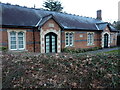
Walmley Almshouses
A group of 4 almshouses at the road junction; they date from 1863, and were Grade II listed https://britishlistedbuildings.co.uk/101116225-walmley-almshouses-4-sutton-coldfield#.X7rhwc37TIU & https://historicengland.org.uk/listing/the-list/list-entry/1116225 in 1976.
Image: © Richard Law
Taken: 11 Mar 2020
0.13 miles
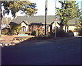
3
Walmley Social Club
Walmley Social Club located on Fox Hollies Road to the East of the Walmley Road junction.
Image: © ROWLAND TURNER
Taken: 6 Jan 2010
0.14 miles
4

Walmley Social Club, Fox Hollies Road, Walmley
Hard to see anything in Walmley except traffic, but Asda is delivering groceries so all's well with the world. The club offers a range of facilities and entertainment for private members https://walmleyclub.org.uk/?fbclid=IwAR2tMwy7x0SHNuRI4JNRdrHYhhQtPA7DHo1Kh8DglJtzY-0Yb4Sku4Ozdos
Image: © Robin Stott
Taken: 19 Oct 2022
0.14 miles
5
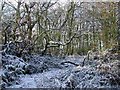
Jones's Wood in winter
Jones's Wood Boxing Day 2004
Image: © ROWLAND TURNER
Taken: 26 Dec 2004
0.14 miles
6
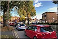
Traffic queuing, Wylde Green Road, Walmley
The shops and services along Walmley Road at Walmley lie between two road junctions: with Wylde Green Road and Fox Hollies Road to the north and Penns Lane and Walmley Ash to the south, making a busy and accessible local centre. There was heavy traffic at the time of this and later photographs.
Image: © Robin Stott
Taken: 19 Oct 2022
0.16 miles
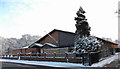
7

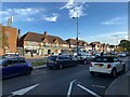
Telephone exchange, Walmley
The building is not identified on our maps but the equipment on the roof and the BT Openreach van are clues.
Image: © Robin Stott
Taken: 19 Oct 2022
0.16 miles
8
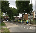
Hi Ho Litter Pickers
20+ members of Sutton Coldfield Litter Action Group head off down Wylde Green Road, on a 7.5 mile round robin litter pickathon and charity day, around all the Sutton wards. In total, 25 bags filled, over 3 hours. Great effort.
Image: © Michael Westley
Taken: 12 Jun 2022
0.18 miles
10
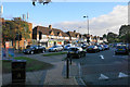
Shops, Walmley Road, Walmley
At the beginning of the 20th century maps show Walmley as a suburban village centre with church, school and pub, with a railway station (Penns) not far away.
Image: © Robin Stott
Taken: 19 Oct 2022
0.18 miles