IMAGES TAKEN NEAR TO
Swale Road, SUTTON COLDFIELD, B76 2BH
Introduction
This page details the photographs taken nearby to Swale Road, B76 2BH by members of the Geograph project.
The Geograph project started in 2005 with the aim of publishing, organising and preserving representative images for every square kilometre of Great Britain, Ireland and the Isle of Man.

There are currently over 7.5m images from over14,400 individuals and you can help contribute to the project by visiting https://www.geograph.org.uk
Image Map
Images are licensed for reuse under creativecommons.org/licenses/by-sa/2.0
Notes
- Clicking on the map will re-center to the selected point.
- The higher the marker number, the further away the image location is from the centre of the postcode.
Image Listing (4 Images Found)
Images are licensed for reuse under creativecommons.org/licenses/by-sa/2.0
Image
Details
Distance
1
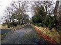
'Natural recycling'
The bypassed section of Fox Hollies Road, Walmley, Sutton Coldfield, gradually being reclaimed by nature.
Image: © ROWLAND TURNER
Taken: 25 Jan 2009
0.10 miles
2
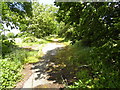
Natural recycling update.
First photographed in 2009; the natural recycling continues apace.
Image: © ROWLAND TURNER
Taken: 2 Jun 2015
0.16 miles
3
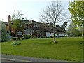
Houses at corner of Brookhus Farm Road and Webster Way, Sutton Coldfield
Same viewpoint but opposite direction to Webster Way image http://www.geograph.org.uk/photo/401764.
Image: © Mike Beeson
Taken: 15 Apr 2007
0.17 miles
4

Signal Hayes Road
Junction of SHR and Fox Hollies Road. Footpath sign '2 miles to Minworth' opposite corner home
Image: © Michael Westley
Taken: 15 May 2010
0.24 miles