IMAGES TAKEN NEAR TO
Hidcote Avenue, SUTTON COLDFIELD, B76 1SA
Introduction
This page details the photographs taken nearby to Hidcote Avenue, B76 1SA by members of the Geograph project.
The Geograph project started in 2005 with the aim of publishing, organising and preserving representative images for every square kilometre of Great Britain, Ireland and the Isle of Man.

There are currently over 7.5m images from over14,400 individuals and you can help contribute to the project by visiting https://www.geograph.org.uk
Image Map
Images are licensed for reuse under creativecommons.org/licenses/by-sa/2.0
Notes
- Clicking on the map will re-center to the selected point.
- The higher the marker number, the further away the image location is from the centre of the postcode.
Image Listing (7 Images Found)
Images are licensed for reuse under creativecommons.org/licenses/by-sa/2.0
Image
Details
Distance
1
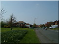
Oak n'Ash (sic) pub, Calder Way, Sutton Coldfield.
The name was not my idea.
Image: © Mike Beeson
Taken: 15 Apr 2007
0.08 miles
2
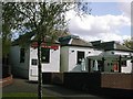
The Oak N' Ash.
The Oak N' Ash Public House is located on the South side, midway along Calder Drive and is the only Public House on the Oak and Ash Estate.
Image: © ROWLAND TURNER
Taken: 14 May 2012
0.08 miles
3
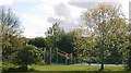
Children's playground.
The newly refurbished children's playground adjacent to Calder Drive.
Image: © ROWLAND TURNER
Taken: 14 May 2012
0.13 miles
4
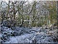
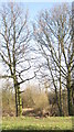
Jones's Wood in winter
Jones's Wood Boxing Day 2004
Image: © ROWLAND TURNER
Taken: 26 Dec 2004
0.17 miles
5
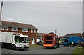
Dustcart convention in Oak Farm Close
"You wait all week for the dustcart to come then three turn up at once".
Image: © ROWLAND TURNER
Taken: 19 Jun 2007
0.23 miles
6
Small wooded area
On outskirts of Walmley, accessed from Turchill Drive
Image: © Michael Westley
Taken: 25 Feb 2012
0.24 miles
7
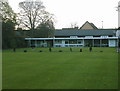
Walmley Bowling Club
Walmley Bowling Club is located in the centre of the village by the Pelican crossing and behind the church hall; on the East side of Walmley Road.
Image: © ROWLAND TURNER
Taken: 16 Nov 2009
0.25 miles