IMAGES TAKEN NEAR TO
Fledburgh Drive, SUTTON COLDFIELD, B76 1ED
Introduction
This page details the photographs taken nearby to Fledburgh Drive, B76 1ED by members of the Geograph project.
The Geograph project started in 2005 with the aim of publishing, organising and preserving representative images for every square kilometre of Great Britain, Ireland and the Isle of Man.

There are currently over 7.5m images from over14,400 individuals and you can help contribute to the project by visiting https://www.geograph.org.uk
Image Map
Images are licensed for reuse under creativecommons.org/licenses/by-sa/2.0
Notes
- Clicking on the map will re-center to the selected point.
- The higher the marker number, the further away the image location is from the centre of the postcode.
Image Listing (16 Images Found)
Images are licensed for reuse under creativecommons.org/licenses/by-sa/2.0
Image
Details
Distance
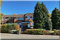
1
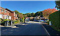
Bassett Close, Sutton Coldfield
Old maps suggest that this area was once part of the New Hall estate.
Image: © Robin Stott
Taken: 18 Oct 2022
0.12 miles
2
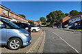
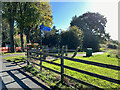
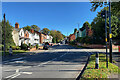
Retford Drive, Sutton Coldfield
Old maps suggest that this area was once part of the New Hall estate. Big old hedgerow oaks put houses in scale.
Image: © Robin Stott
Taken: 18 Oct 2022
0.13 miles
3
Far Highfield, Sutton Coldfield
From the top of Lisures Drive. Old maps suggest that this area was once part of the New Hall estate.
Image: © Robin Stott
Taken: 18 Oct 2022
0.14 miles
4
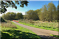
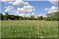
Into Newhall Valley Country Park, Sutton Coldfield
The path was once a lane past Newhall Farm to New Hall.
Image: © Robin Stott
Taken: 18 Oct 2022
0.15 miles
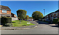
5
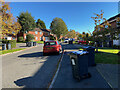
Bin day, Lisures Drive, Sutton Coldfield
Old maps suggest that this area was once part of the New Hall estate.
Image: © Robin Stott
Taken: 18 Oct 2022
0.15 miles
6
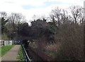
Cycle route 534
The cycle path heads east beside Plants Brook as they approach the shared culvert beneath the freight line between Water Orton and Walsall.
Image: © Tim Glover
Taken: 13 Mar 2017
0.16 miles
7
Way in to Newhall Valley Country Park, Sutton Coldfield
A shared path off Coleshill Road offers a pleasanter way to Walmley.
Image: © Robin Stott
Taken: 18 Oct 2022
0.19 miles
8
Reddicap Hill, Sutton Coldfield
Leaving Coleshill Road behind, it climbs through Reddicap Heath to a north-south ridge and the busy B4148.
Image: © Robin Stott
Taken: 18 Oct 2022
0.19 miles
9
Retford Drive, Sutton Coldfield
Old maps suggest that this area was once part of the New Hall estate. Trees up the hill are in Home Wood, barely accessible abandoned woodland.
Image: © Robin Stott
Taken: 18 Oct 2022
0.20 miles