1
Sutton Coldfield Town railway station (site), Birmingham
Opened as "Sutton Coldfield" in 1879 by the Midland Railway on the line from Castle Bromwich to Walsall, "Town" was added to the name from 1882 to 1904, dropped 1904-1924, then added back in 6 months before closure. The station closed to passengers at the end of 1924.
Former forecourt view on Midland Drive.
Image: © Nigel Thompson
Taken: 22 Oct 2011
0.11 miles
2
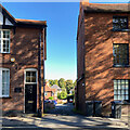
Church House Drive, Sutton Coldfield
Some twentieth-century houses are tucked away behind much older Coleshill Street. On the left is No 13; on the right No 15, Church House, listed Grade II. Behind the camera is Holy Trinity churchyard.
Image: © Robin Stott
Taken: 18 Oct 2022
0.16 miles
3
Estate Agent, 8 High Street, corner of Midland Drive
These were the premises of Knight Frank at the time of the photograph. This entertaining – sorry, eclectic – building is not listed. The English Heritage map shows it as a bank. How should it be characterized: Edwardian Postmodern? The welter of features and the craftsmanship also suggest that this is an advertisement for the architect.
Image: © Robin Stott
Taken: 22 Sep 2012
0.16 miles
4
Sutton Coldfield cemetery
The gated entrance and former chapel at Sutton Coldfield cemetery.
Image: © Keith Evans
Taken: 27 Oct 2007
0.16 miles
5
Mill Street, Sutton Coldfield
Image: © Chris Whippet
Taken: 8 Dec 2008
0.16 miles
6
High Street, Sutton Coldfield
Sutton Coldfield's High Street, the Georgian style building actually dates from the early 20th century. The building is Grade II listed, see:https://historicengland.org.uk/listing/the-list/list-entry/1075831?section=official-list-entry
Image: © Philip Halling
Taken: 17 May 2018
0.17 miles
7
East side of Coleshill Street, Sutton Coldfield
A pleasing range of buildings, some of which are listed.
Image: © Robin Stott
Taken: 18 Oct 2022
0.17 miles
8
Coleshill Street, Sutton Coldfield
Looking towards High Street, straight ahead, although this is not the town's main shopping area.
Image: © Stephen McKay
Taken: 11 Dec 2013
0.17 miles
9
High Street - Sutton Coldfield, West Midlands
A view southwards on the High Street in Sutton Coldfield . On the right, beyond the Three Tuns Hotel and the green sign of the Jobcentre, is the junction with Railway Road with Sutton Coldfield Railway Station on its southern side. On the right of the photo is sited one of the many defibrillators which have appeared in towns and villages and other sites around Britain. Time photo taken 3.01 pm GMT (Greenwich Mean Time).
Image: © Martin Richard Phelan
Taken: 26 Feb 2020
0.17 miles
10
Playing Field, Bishop Vesey's School
Image: © Roy Hughes
Taken: 26 Apr 2014
0.18 miles


