IMAGES TAKEN NEAR TO
Bedford Road, SUTTON COLDFIELD, B75 6DB
Introduction
This page details the photographs taken nearby to Bedford Road, B75 6DB by members of the Geograph project.
The Geograph project started in 2005 with the aim of publishing, organising and preserving representative images for every square kilometre of Great Britain, Ireland and the Isle of Man.

There are currently over 7.5m images from over14,400 individuals and you can help contribute to the project by visiting https://www.geograph.org.uk
Image Map
Images are licensed for reuse under creativecommons.org/licenses/by-sa/2.0
Notes
- Clicking on the map will re-center to the selected point.
- The higher the marker number, the further away the image location is from the centre of the postcode.
Image Listing (3 Images Found)
Images are licensed for reuse under creativecommons.org/licenses/by-sa/2.0
Image
Details
Distance
1
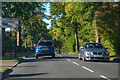
Sutton Coldfield : Tamworth Road A453
Heading along the A453.
Image: © Lewis Clarke
Taken: 26 Sep 2020
0.17 miles
2
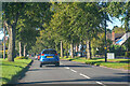
Sutton Coldfield : Tamworth Road A453
Heading along the A453.
Image: © Lewis Clarke
Taken: 26 Sep 2020
0.18 miles
3
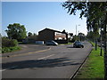
Lindridge Road junction
Junction with Whitehouse Common Road, north-east of Sutton Coldfield town
Image: © Michael Westley
Taken: 10 Oct 2010
0.22 miles