IMAGES TAKEN NEAR TO
Holt Court South, Jennens Road, BIRMINGHAM, B7 4EJ
Introduction
This page details the photographs taken nearby to Holt Court South, Jennens Road, B7 4EJ by members of the Geograph project.
The Geograph project started in 2005 with the aim of publishing, organising and preserving representative images for every square kilometre of Great Britain, Ireland and the Isle of Man.

There are currently over 7.5m images from over14,400 individuals and you can help contribute to the project by visiting https://www.geograph.org.uk
Image Map (Loading...)


Getting Data...Please wait
Leaflet Map data © OpenStreetMap
Images are licensed for reuse under creativecommons.org/licenses/by-sa/2.0
Notes
- Clicking on the map will re-center to the selected point.
- The higher the marker number, the further away the image location is from the centre of the postcode.
Image Listing (217 Images Found)
Images are licensed for reuse under creativecommons.org/licenses/by-sa/2.0
Image
Details
Distance
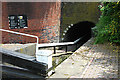
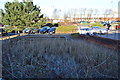
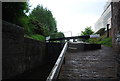
3
Ashted Top Lock on the Digbeth Branch Canal
Next to the northwest portal of the Ashted Tunnel in the Nechells Green area of Birmingham.
Image: © Mat Fascione
Taken: 27 Sep 2015
0.02 miles
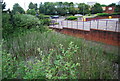
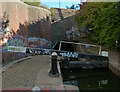
5
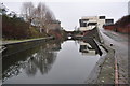
Birmingham and Fazeley Canal
A view of the canal with a bridge to the right over a long lost arm to a local factory or industry. There is a slight widening here for boats waiting to travel through Ashted canal tunnel (behind me) Image]
Image: © Ashley Dace
Taken: 19 Feb 2011
0.02 miles