IMAGES TAKEN NEAR TO
Clarence Road, SUTTON COLDFIELD, B74 4LE
Introduction
This page details the photographs taken nearby to Clarence Road, B74 4LE by members of the Geograph project.
The Geograph project started in 2005 with the aim of publishing, organising and preserving representative images for every square kilometre of Great Britain, Ireland and the Isle of Man.

There are currently over 7.5m images from over14,400 individuals and you can help contribute to the project by visiting https://www.geograph.org.uk
Image Map
Images are licensed for reuse under creativecommons.org/licenses/by-sa/2.0
Notes
- Clicking on the map will re-center to the selected point.
- The higher the marker number, the further away the image location is from the centre of the postcode.
Image Listing (6 Images Found)
Images are licensed for reuse under creativecommons.org/licenses/by-sa/2.0
Image
Details
Distance
1
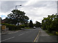
Clarence Road, Hill Hook
Close to the halfway point.
Image: © Richard Vince
Taken: 3 Jun 2017
0.03 miles
2
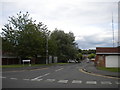
West end of Weymouth Drive, Hill Hook
Seen from Clarence Road. On the right, the Sutton Coldfield television transmitter (about half a mile away) is visible.
Image: © Richard Vince
Taken: 3 Jun 2017
0.05 miles
3
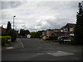
Kensington Drive, Hill Hook
Seen from Weymouth Drive.
Image: © Richard Vince
Taken: 3 Jun 2017
0.10 miles
4
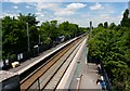
Butlers Lane Station
Looking north towards Blake Street station and Lichfield, from the Butlers Lane road bridge.
See also Image
Image: © Graham Taylor
Taken: 4 Jun 2008
0.22 miles
5
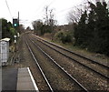
Cross-City Line north of Butlers Lane railway station, Sutton Coldfield
Viewed from platform 2. Next station ahead is Blake Street on the route to Lichfield.
Image: © Jaggery
Taken: 17 Feb 2018
0.22 miles
6
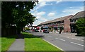
Clarence Road Shops
A small parade of shops serving the local community. Just visible at the far end is a filling station. Behind the shops is the Four Oaks Saints Cricket Club and beyond that the Hill Hook Local Nature Reserve.
Image: © Graham Taylor
Taken: 4 Jun 2008
0.24 miles