IMAGES TAKEN NEAR TO
Wyvern Close, SUTTON COLDFIELD, B74 2QD
Introduction
This page details the photographs taken nearby to Wyvern Close, B74 2QD by members of the Geograph project.
The Geograph project started in 2005 with the aim of publishing, organising and preserving representative images for every square kilometre of Great Britain, Ireland and the Isle of Man.

There are currently over 7.5m images from over14,400 individuals and you can help contribute to the project by visiting https://www.geograph.org.uk
Image Map
Images are licensed for reuse under creativecommons.org/licenses/by-sa/2.0
Notes
- Clicking on the map will re-center to the selected point.
- The higher the marker number, the further away the image location is from the centre of the postcode.
Image Listing (22 Images Found)
Images are licensed for reuse under creativecommons.org/licenses/by-sa/2.0
Image
Details
Distance
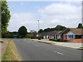
1
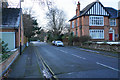
Barker Road
A residential street directly off Lichfield Road.
Image: © Bill Boaden
Taken: 8 Dec 2017
0.09 miles
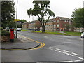
2
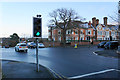
Crossroads on Lichfield Road
The A453 meets the A5127 a little to the north of the town centre.
Image: © Bill Boaden
Taken: 8 Dec 2017
0.09 miles
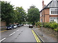

5
Tamworth Road
The A453 near its beginning on Lichfield Road.
Image: © Bill Boaden
Taken: 8 Dec 2017
0.11 miles
7
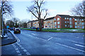
Blocks of flats on Lichfield Road
Private apartments in a large residential area.
Image: © Bill Boaden
Taken: 8 Dec 2017
0.13 miles
8

Sutton Coldfield : Tamworth Road A453
Heading along the A453.
Image: © Lewis Clarke
Taken: 26 Sep 2020
0.15 miles
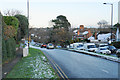
10
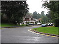
Sutton Coldfield - Rockingham Gardens
Residential area very close to the centre of Sutton Coldfield.
Image: © Peter Whatley
Taken: 22 Sep 2008
0.19 miles