IMAGES TAKEN NEAR TO
Welshmans Hill, SUTTON COLDFIELD, B73 6RE
Introduction
This page details the photographs taken nearby to Welshmans Hill, B73 6RE by members of the Geograph project.
The Geograph project started in 2005 with the aim of publishing, organising and preserving representative images for every square kilometre of Great Britain, Ireland and the Isle of Man.

There are currently over 7.5m images from over14,400 individuals and you can help contribute to the project by visiting https://www.geograph.org.uk
Image Map
Images are licensed for reuse under creativecommons.org/licenses/by-sa/2.0
Notes
- Clicking on the map will re-center to the selected point.
- The higher the marker number, the further away the image location is from the centre of the postcode.
Image Listing (12 Images Found)
Images are licensed for reuse under creativecommons.org/licenses/by-sa/2.0
Image
Details
Distance
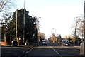
2
Chester Road North heading to Banners Gate
Image: © Steve Daniels
Taken: 10 Jan 2015
0.17 miles
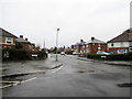
3

Early May morning on Hatcham Road - Kingstanding, North Birmingham
View northwards on Hatcham Road from its junction with Kings Road. Council house building started in Birmingham in 1919 and the largest estate was Kingstanding with 4802 houses on 493 acres, although with Right to Buy some have been sold to their tenants. Time photo taken 06.40 am BST (British Summer Time).
Image: © Martin Richard Phelan
Taken: 16 May 2014
0.17 miles
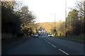
4
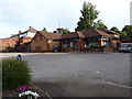
The Mount Tavern, New Oscott
Located on the north side of King's Road, this former pub now seems to be an Indian Grill and restaurant.
Image: © Richard Law
Taken: 9 Aug 2018
0.21 miles
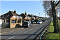
5
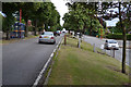
Split-level stretch of King's Road, between Kingstanding and New Oscott, Birmingham
King's Road is running obliquely along the flank of a ridge. This is near the junction with Tottenham Crescent, right Image Steps make it safer to reach a bus stop from across the road.
Image: © Robin Stott
Taken: 4 Aug 2016
0.22 miles
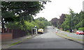
6
Banners Walk, Kingstanding
View from almost top of path, looking south. Sustrans cycle route signs ahead
Image: © Michael Westley
Taken: 22 May 2010
0.22 miles
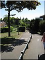
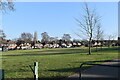
8
The Greenway - Sutton Coldfield, West Midlands
A residential road in Sutton Coldfield leading southwards from Banners Gate Road Time photo taken 3.27 pm GMT (Greenwich Mean Time)
Image: © Martin Richard Phelan
Taken: 28 Feb 2021
0.23 miles
9
Sutton Coldfield, Chester Road North A452
Image: © Roy Hughes
Taken: 1 Jun 2011
0.24 miles
10
From cycleway to The Greenway - Sutton Coldfield, West Midlands
Looking from the cycleway where it crosses Banners Gate Road towards The Greenway. The cycleway runs from Sutton Coldfield via Perry Common and Aston into Birmingham. Time photo taken 3.23 pm GMT (Greenwich Mean Time).
Image: © Martin Richard Phelan
Taken: 28 Feb 2021
0.24 miles