IMAGES TAKEN NEAR TO
B73 5ZQ
Introduction
This page details the photographs taken nearby to B73 5ZQ by members of the Geograph project.
The Geograph project started in 2005 with the aim of publishing, organising and preserving representative images for every square kilometre of Great Britain, Ireland and the Isle of Man.

There are currently over 7.5m images from over14,400 individuals and you can help contribute to the project by visiting https://www.geograph.org.uk
Image Map
Images are licensed for reuse under creativecommons.org/licenses/by-sa/2.0
Notes
- Clicking on the map will re-center to the selected point.
- The higher the marker number, the further away the image location is from the centre of the postcode.
Image Listing (14 Images Found)
Images are licensed for reuse under creativecommons.org/licenses/by-sa/2.0
Image
Details
Distance
1
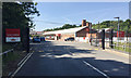
Royal Mail Delivery Office, Sutton Coldfield
A relatively new building at the end of a road off Station Approach. The long-gone station was Sutton Park Station on the Water Orton to Walsall line, now freight only, that runs at the back of the Royal Mail site: Image
Image: © Robin Stott
Taken: 28 Jun 2018
0.06 miles
2
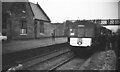
Railtour at Sutton Park Station
Sutton Park station was on the line between Castle Bromwich & Walsall opened by the Midland Railway in July 1879. Closure to passengers came in January 1965 & the station buildings have been demolished. The line remains open for goods traffic.
The 'Birmingham Area Railtour' organised by the Birmingham University Transport Society took us from Walsall in the north to Stratford in the south, Leamington in the east to Alveley Colliery (near Highley) in the west. Details of the route can be found on the Six Bells Junction website http://www.sixbellsjunction.co.uk/ .
Image: © Martin Tester
Taken: 2 Mar 1968
0.09 miles
3
Working on the line
Men at work on the freight-only line which links Bescot marshalling yard with the routes to Derby and Nuneaton.
Image: © Peter Whatley
Taken: 22 Sep 2008
0.11 miles
4
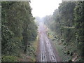
Sutton Park railway station (site), Birmingham
Opened in 1879 by the Midland Railway on the line from Castle Bromwich to Walsall, this station closed to passengers in 1965.
View north west towards Streetley and Walsall.
Image: © Nigel Thompson
Taken: 16 Oct 2011
0.12 miles
5
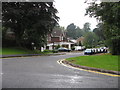
Sutton Coldfield - Rockingham Gardens
Residential area very close to the centre of Sutton Coldfield.
Image: © Peter Whatley
Taken: 22 Sep 2008
0.16 miles
6
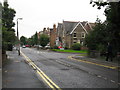
Sutton Coldfield - Anchorage Road
A road seemingly full of rest homes, plus the police station.
Image: © Peter Whatley
Taken: 22 Sep 2008
0.20 miles
7
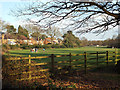
Informal recreation space, Sutton Park
The houses overlooking the park are in Aragon Drive.
Image: © Robin Stott
Taken: 6 Apr 2015
0.21 miles
8

Going to and from the Hartopp gate, Sutton Park
Late afternoon on a bright Easter Monday. The people on the right are a group of Asian friends. The road passes through some characteristic vegetation – oak woodland with a dense understorey of holly.
Image: © Robin Stott
Taken: 6 Apr 2015
0.21 miles
9
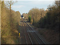
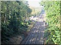
Southeast on the Sutton Park Line
The view is towards Sutton Coldfield. Since 1964 the line has carried only freight and excursions.
Image: © Robin Stott
Taken: 6 Apr 2015
0.22 miles
10
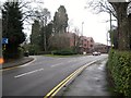
Upper Clifton Road - Sutton Coldfield, West Midlands
A view eastwards on Upper Clifton Road – on the left is Clifton Drive and the access to the Royal Mail Sorting Office. Time photo taken 1.42 pm GMT (Greenwich Mean Time).
Image: © Martin Richard Phelan
Taken: 4 Jan 2018
0.23 miles