IMAGES TAKEN NEAR TO
Chester Road, SUTTON COLDFIELD, B73 5JS
Introduction
This page details the photographs taken nearby to Chester Road, B73 5JS by members of the Geograph project.
The Geograph project started in 2005 with the aim of publishing, organising and preserving representative images for every square kilometre of Great Britain, Ireland and the Isle of Man.

There are currently over 7.5m images from over14,400 individuals and you can help contribute to the project by visiting https://www.geograph.org.uk
Image Map (111 Images)


Leaflet Map data © OpenStreetMap
Images are licensed for reuse under creativecommons.org/licenses/by-sa/2.0
Notes
- Clicking on the map will re-center to the selected point.
- The higher the marker number, the further away the image location is from the centre of the postcode.
Image Listing (111 Images Found)
Images are licensed for reuse under creativecommons.org/licenses/by-sa/2.0
Image
Details
Distance
1
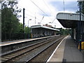
Chester Road Station
On the Lichfield - Redditch Cross City line.
Image: © David Stowell
Taken: 8 Jul 2006
0.01 miles
2
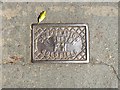
Fire hydrant cover, Chester Road, north Birmingham
The cast-iron cover is identified by CORPORATION / OF SUTTON / F H / COLDFIELD. Now part of the City of Birmingham, the Royal Borough of Sutton Coldfield extended a long way south. This cover is outside no 645 Chester Road, near the station, about 3.5 km from the town hall.
Image: © Robin Stott
Taken: 27 Jun 2018
0.02 miles
3

Delayed ? and the rest !
Winter rail delays 2010 style. The sign says it all - trains getting back on time, but earlier trains, not yet cancelled, are 3 hours late.
Information board on platform at Chester Road Station
Image: © Michael Westley
Taken: 18 Dec 2010
0.02 miles
4
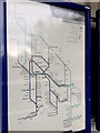
Diagrammatic map of railway network, Chester Road station, Birmingham
The map shows the places served in the West Midlands Railway and London Northwestern Railway franchises.
Image: © Robin Stott
Taken: 9 Jul 2019
0.02 miles
5

Birmingham Railway Map
As displayed at Chester Road station, May 2023.
Photo number 7567411.
Image: © Robin Stott
Taken: 29 May 2023
0.02 miles
6
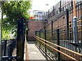
Ramp, Chester Road station, Birmingham
It connects Green Lanes to Platform 1. Chester Road is a station on the Cross-City Line between Redditch, Bromsgrove and Lichfield. There are frequent well-used services by West Midlands Railways.
Image reference: 7510269
Image: © Robin Stott
Taken: 29 May 2023
0.03 miles
7
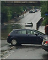
Flood below the railway bridge at Chester Road, north Birmingham
After a night of thunderstorms and rain, a downpour on the afternoon of 27 May 2018 ("a month's rain in an hour") produced a flood in the dip of the road below the bridge. A car was abandoned; other traffic found ways round. Flashing blue lights were placed by the car as a warning. Rain, sometimes heavy, continued through the evening, accompanied by thunder and lightning. By 20:30 the car had been removed, the rain had stopped, and the flood had largely drained away. In Walsall an 80-year old man died after being rescued from a car caught in floodwater.
Image: © Mo Westrop
Taken: 27 May 2018
0.03 miles
8
Bridge over Chester Road south of Chester Road station, north Birmingham
This bridge over the busy A452 Chester Road is barely noticeable. Compare Roy Hughes' view from the road: Image The small green sign on the fence is for the Samaritans https://www.samaritans.org , hoping to give would-be suicides pause for thought. It reads "Talk to us if things are getting to you", with a phone number.
Image: © Robin Stott
Taken: 9 Jul 2019
0.03 miles
9

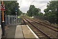
Chester Road railway station, Birmingham
Opened in 1863 by the London & North Western Railway on the line from Birmingham New Street to Lichfield. View north towards Wylde Green and Lichfield.
Image: © Nigel Thompson
Taken: 22 Oct 2011
0.03 miles
10

Footpath to and from down platform, Chester Road station, north Birmingham
On a bright early November day.
Image: © Robin Stott
Taken: 5 Nov 2017
0.03 miles